

Tour from Lacona up/down to the Mt. Tambone, also tour up/down from Marina di Campo to Mt. Tambone.
Down the trail is difficult but ok.
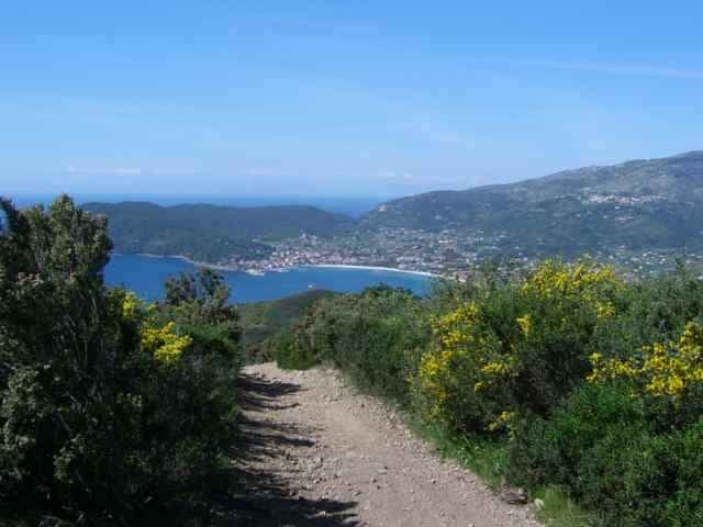
There is another tour from Locana to the Mt. Tambone back to Lacona. The beginnung from Lacona to half of Mt. Tambone uses the street (see the other track for an alternative uphill).
I drove this tour with the Mt. Perone Pietra Maruta Tour (see there).
Down the trail is difficult but ok.
There is another tour from Locana to the Mt. Tambone back to Lacona. The beginnung from Lacona to half of Mt. Tambone uses the street (see the other track for an alternative uphill).
I drove this tour with the Mt. Perone Pietra Maruta Tour (see there).
Další informace v části
http://www.gps-tour.info/tours/view.php?action=view&entity=list&limitstart=0&country=Italien&federal=ToskanaGalerie tras

Trasa mapa a výškový profil
Minimální výška 3 m
Maximální výška 380 m
Více o autorovi turné
|
|
skyhopper |
Komentáře
Portoferrario, Locana, at the village end of Lacona in direction to Marina di Campo park the car (or come from Marina di Campo - see Capane tour for description).
Trasy GPS
Trackpoints-
GPX / Garmin Map Source (gpx) download
-
TCX / Garmin Training Center® (tcx) download
-
CRS / Garmin Training Center® (crs) download
-
Google Earth (kml) download
-
G7ToWin (g7t) download
-
TTQV (trk) download
-
Overlay (ovl) download
-
Fugawi (txt) download
-
Kompass (DAV) Track (tk) download
-
Formulář trasy (pdf) download
-
Původní soubor autora (gpx) download
Více o autorovi turné
|
|
skyhopper |
Přidat do oblíbených
Odebrat z oblíbených položek
Upravit značky
Open track
Moje hodnocení
Hodnotit
Strecke abgefahren
1. Die Abfahrt nach Lacona ist mit Schiebepassagen versehen, besonders in der unteren Hälfte (auch für Geübte).
2. Die Auffahrt von Marina di Campo ist teilweise steil und in der oberen Hälfte etwas Verblockt.
3. Würde die Abfahrt nach Lancona über die Schotterpiste nehmen (Marathonstrecke), da diese auch sehr verblockt ist aber dafür mit super Aussicht auf die Laconabucht.
S3 Trails