Login

Login oublié ?

Cookies have to be accepted!
Your browser's cookie functionality is disabled. Please enable this functionality.

Not a member yet?

Register now
Login

Available for registred users only

Log in to use this feature.

Login oublié ?

Cookies have to be accepted!
Your browser's cookie functionality is disabled. Please enable this functionality.

Not a member yet?

Register now
Filter
Catégories
Advanced filters
  • Longueur (km)
  • Altimètre
Enregistrer le filtre Reset filter

TrackRank

QRCode

Technical data

Longueur48,6 km Altimètre1172 m Way down1151 m Durée03:30 h:m Date27.05.2012
Evaluations Author User Paysage Aspect amusement Condition Technique

Statistiques

927 Vues 3 Evaluations 168 Téléchargements 3.33 Moyenne
Rate
  • Feuille de tours
  • Arrivée
  • Téléchargements
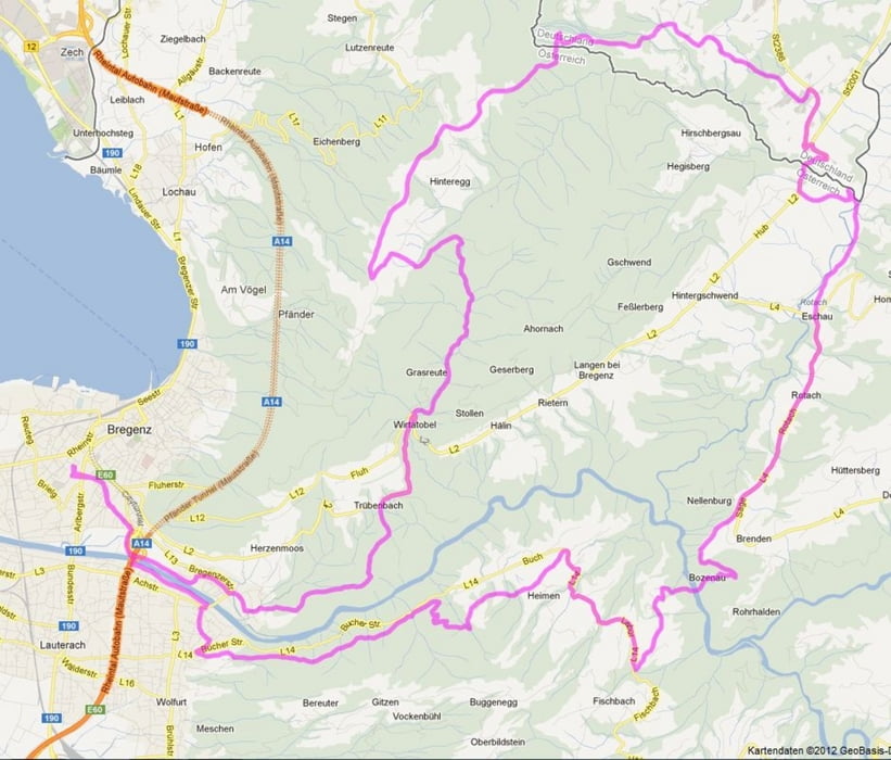
abwechslungsreiche Tour am Pfänder und durch den Vorderwald, größtenteils auf Waldwegen und Trails, Asphalt nur dort wo es keine Alternative im Gelände gibt

Carte du tour et altitude

  • Open Street Map
  • Google
Minimum height 386 m Maximum height 1020 m Vue de détail

More about the tour author

Winni345
Member since 2010

Send private message

Commentaires

Odin on 26.08.2014

Gefahren am 22.08.2014

Der erste Aufstieg ist soweit ganz ok - schöner Schotterweg am Wiratobel entlang. Vorher leider auch ein ganzes Stück Straße. Die erste Abfahrt beginnt dann mit einem kurzen anspruchsvollen Streckenabschnitt, danach bis zum 2. Anstieg ausschließlich Straße. Hier hätte es sicher eine brauchbare Alternative im Gelände gegeben. Der 2. Anstieg dann kurz und steil, aber fahrbar. Der Rest (bis auf die letzten 3Km im Wald einem netten Trail folgend) auch wieder nur Straße.
Fazit: Die Tour passt leider nicht zur Streckenbeschreibung: "Asphalt nur wo es keine Alternativen im Gelände gibt" stimmt hier leider nicht.
Start und Ziel: Bregenz

Tracks GPS

Trackpoints
  • GPX / Garmin Map Source (gpx) download
  • TCX / Garmin Training Center® (tcx) download
  • CRS / Garmin Training Center® (crs) download
  • Google Earth (kml) download
  • G7ToWin (g7t) download
  • TTQV (trk) download
  • Overlay (ovl) download
  • Fugawi (txt) download
  • Kompass (DAV) Track (tk) download
  • Feuille de tours (pdf) download
  • Original file of the author (gpx) download

More about the tour author

Winni345
Member since 2010

Send private message
Share track
Add to my favorites
Remove from my favorites
Edit tags
My score
Rate
Tour: Pfänder/Vorderwald
Cat.: Mountainbike
Longueur: 48,6 km
Evaluated on:
Durée:
Day(s)
Hour(s)
Minute(s)
Evaluation: Paysage Aspect amusement Condition Technique