Login

Si pozabil/a podatke za prijavo?

Cookies have to be accepted!
Your browser's cookie functionality is disabled. Please enable this functionality.

Not a member yet?

Register now
Login

Available for registred users only

Log in to use this feature.

Si pozabil/a podatke za prijavo?

Cookies have to be accepted!
Your browser's cookie functionality is disabled. Please enable this functionality.

Not a member yet?

Register now
Filter
Kategorije
Advanced filters
  • Dolžina (km)
  • Metri nadmorske višine
Shrani filter Reset filter

TrackRank

QRCode

Technical data

Dolžina19,7 km Metri nadmorske višine197 m Way down199 m Trajanje01:00 h:m Datum06.05.2014
Ocene Author Pokrajina Dejavnik zabave Kondicija Tehnika

Statistika

103 Pogledi Ocene 4 Prenosi Povprečje
Rate
  • List z izleti
  • Prihod
  • Prenosi

Nette Runde von Schwarzenbach nach Kirkel und zurück.

Den Rückweg nahm ich an diesem Tag über den netten Pass in das Taubental.


Further information at

https://de.wikipedia.org/wiki/Bundesautobahn_998

Galerija izletov

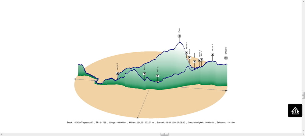
Zemljevid in višinski profil izleta

  • Open Street Map
  • Google
Minimum height 221 m Maximum height 323 m Prikaz podrobnosti

More about the tour author

Pheinz
Member since 2009

Send private message

Komentarji

In Schwarzenbach geht es los.

Poti GPS

Trackpoints
  • GPX / Garmin Map Source (gpx) download
  • TCX / Garmin Training Center® (tcx) download
  • CRS / Garmin Training Center® (crs) download
  • Google Earth (kml) download
  • G7ToWin (g7t) download
  • TTQV (trk) download
  • Overlay (ovl) download
  • Fugawi (txt) download
  • Kompass (DAV) Track (tk) download
  • List z izleti (pdf) download
  • Original file of the author (gpx) download

More about the tour author

Pheinz
Member since 2009

Send private message
Share track
Add to my favorites
Remove from my favorites
Edit tags
My score
Rate
Izlet: 140409-Tagestour
Vrsta: Izleti s kolesom
Dolžina: 19,7 km
Evaluated on:
Trajanje:
Day(s)
Hour(s)
Minute(s)
Ocena: Pokrajina Dejavnik zabave Kondicija Tehnika