Bericht: Paddel-Tour Spreewald (eine kleine Runde)
Paddel-Tour mit meiner Tochter im Spreewald. Wir parken am Bahnhof und fahren mit dem Rad zum Bootshaus Kaupen und leihen uns dort ein Kajak.
Aufgrund der Hitze hat uns der Inhaber des Bootshauses eine kleinere (schattigere) Runde von ca. 12km empfohlen.
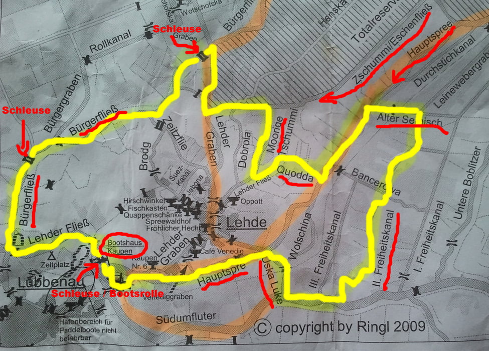
Wir starten am Bootshaus und fahren Richtung Hauptspree. Wir biegen rechts in die Uska Luke ein und fahren zum Südumfluter. Wir biegenlinks in den II. Freiheitskanal ein und fahren bis Alter Semisch. An der Brücken machen wir eine Pause.
Links geht auf auf die Hauptspree bis rechts Abzweig Quodda, dann rechts in den Moorige bis zum Zschummi/Eschenfließ. Links bis zum Lehder Graben dann in den Bürgerfließ. Die 1te Schleuse. Weiter den Bürgerfließ zur 2ten Schleuse.
Wir biegen links in den Lehder Fließ und fahren zurück zum Bootshaus.
Fazit:
- schöne kleine Runde
- man sollte unbedingt Mittel gegen Mücken mithaben
Hier noch unsere Rad-Tour vom Spreewald-Kurztripp ... klick hier
Tour gallery
Tour map and elevation profile
Comments

GPS tracks
Trackpoints-
GPX / Garmin Map Source (gpx) download
-
TCX / Garmin Training Center® (tcx) download
-
CRS / Garmin Training Center® (crs) download
-
Google Earth (kml) download
-
G7ToWin (g7t) download
-
TTQV (trk) download
-
Overlay (ovl) download
-
Fugawi (txt) download
-
Kompass (DAV) Track (tk) download
-
Track data sheet (pdf) download
-
Original file of the author (gpx) download


