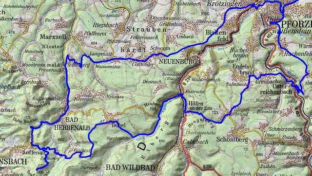
Anspruchsvolle Tour von Nussdorf über Oeschelbronn Niefern nach Pfozheim Kupferhammer. Dann Huchenfeld Hohenwart, Unterreichenbach, Grunbach, Langenbrand nach Höfen. Auf verkehrsarmen Nebenstraßen zwischen Eyachmühle, Dobel und Weithäuselsplatz zur Teufelsmühle bei Loffenau. Zurück über Bad Herrenalb, Schielberg, Conweiler, Schwann und Birkenfeld.
Alle Strassen Asphalt. Im Eyachtal ein kurzes Stück Kopfsteinpflaster.
Alle Strassen Asphalt. Im Eyachtal ein kurzes Stück Kopfsteinpflaster.
Further information at
http://www.quaeldich.de/Paesse.pl?PassID=199Tour gallery
Tour map and elevation profile
Minimum height 239 m
Maximum height 886 m
Comments
GPS tracks
Trackpoints-
GPX / Garmin Map Source (gpx) download
-
TCX / Garmin Training Center® (tcx) download
-
CRS / Garmin Training Center® (crs) download
-
Google Earth (kml) download
-
G7ToWin (g7t) download
-
TTQV (trk) download
-
Overlay (ovl) download
-
Fugawi (txt) download
-
Kompass (DAV) Track (tk) download
-
Track data sheet (pdf) download
-
Original file of the author (gpx) download
Add to my favorites
Remove from my favorites
Edit tags
Open track
My score
Rate


Forumstour