Login

Forgotten password?

Cookies have to be accepted!
Your browser's cookie functionality is disabled. Please enable this functionality.

Not a member yet?

Register now
Login

Available for registred users only

Log in to use this feature.

Forgotten password?

Cookies have to be accepted!
Your browser's cookie functionality is disabled. Please enable this functionality.

Not a member yet?

Register now
Filter
Categories
Advanced filters
  • Distance (km)
  • Height
Save filters Reset filter

TrackRank

QRCode

Technical data

Distance18,1 km Height587 m Way down505 m Duration05:00 h:m Date26.08.2008
Scores Author Landscape Fun factor Fitness Technique

Statistics

515 Views Scores 103 Downloads Average
Rate
  • Track data sheet
  • Directions
  • Downloads

23.08.2008

sehr schöne Tour,

vorbei am Golfplatz

dann an den Härtsfeldsee, Mittagsrast am Kiosk.

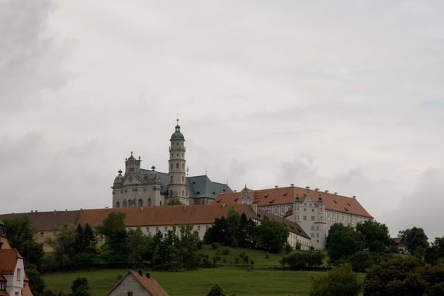
weiter vorbei an Burg Katzenstein und zurück über die Klosterkirche Neresheim.

- absolut sehenswert

Further information at

http://www.neresheim.de

Tour gallery

Tour map and elevation profile

  • Open Street Map
  • Google
Minimum height 412 m Maximum height 718 m Detailed view

More about the tour author

plattfuss
Member since 2007

Send private message

Comments

A96

Abfahrt Neresheim,

parken am Friedhof (kostenlos)

GPS tracks

Trackpoints
  • GPX / Garmin Map Source (gpx) download
  • TCX / Garmin Training Center® (tcx) download
  • CRS / Garmin Training Center® (crs) download
  • Google Earth (kml) download
  • G7ToWin (g7t) download
  • TTQV (trk) download
  • Overlay (ovl) download
  • Fugawi (txt) download
  • Kompass (DAV) Track (tk) download
  • Track data sheet (pdf) download
  • Original file of the author (gpx) download

More about the tour author

plattfuss
Member since 2007

Send private message
Share track
Add to my favorites
Remove from my favorites
Edit tags
My score
Rate
Track: wandern bei Neresheim
Type: Hiking
Distance: 18,1 km
Evaluated on:
Duration:
Day(s)
Hour(s)
Minute(s)
Score: Landscape Fun factor Fitness Technique