


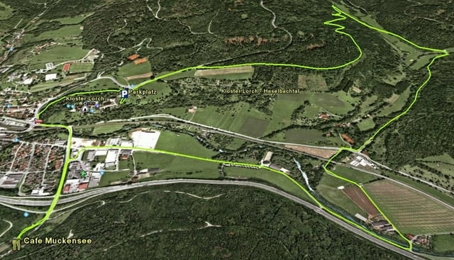
Start un Ziel ist das Kloster Lorch im Remstal. Für eine Besichtigung sollte man min. 1-2h Zeit einplanen. Besonders das Stauferrundbild lohnt einen Besuch. Nähere Infos zum Kloster findet man auch unter: www.hans-kloss.de/hkrundbild.htm
Auf halber Höhe geht es durch den Wald ins Haselbachtal. Entlang der Rems geht es dann zurück nach Lorch. Unterwegs kann noch das Rückhaltebecken an der Rems besichtigt werden.
Wieder in Lorch bietet sich dann das Cafe Muckensee als Einkehrmöglichkeit an. Von dort geht es dann wieder zurück zum Parkplatz am Kloster Lorch.
Further information at
http://www.stadt-lorch.de/kultur/staufer.htmlTour gallery
Tour map and elevation profile
Minimum height 237 m
Maximum height 384 m
More about the tour author

|
ruph |
Comments

GPS tracks
Trackpoints-
GPX / Garmin Map Source (gpx) download
-
TCX / Garmin Training Center® (tcx) download
-
CRS / Garmin Training Center® (crs) download
-
Google Earth (kml) download
-
G7ToWin (g7t) download
-
TTQV (trk) download
-
Overlay (ovl) download
-
Fugawi (txt) download
-
Kompass (DAV) Track (tk) download
-
Track data sheet (pdf) download
-
Original file of the author (gpx) download
More about the tour author
|
|
ruph |
Add to my favorites
Remove from my favorites
Edit tags
Open track
My score
Rate