


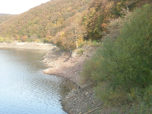
Eifeler Steilküste
Der Weg führt entlang des Rurseeufers, dann hoch nach Schmidt und zurück durch den Hürtgenwalder Staatsforst mit Blick auf den Rursee. Der Stausee gehört mit einer überstauten Fläche von 780 ha und einem Fassungsvermögen von 203 Millionen m³ zu den größten Talsperren Deutschlands. Bei Niedrigwasser zeigt sich ein schroffer Schieferabhang, der dem Weg den Namen "Steilküste" einbrachte.
Für Kinderwagen ungeeignet.
Einkehrmöglichkeiten gibt es in Hasenfeld , Schwammenauel,und Schmidt
Further information at
http://www.ferienwohnung-dick.com/Tour gallery

Tour map and elevation profile
Minimum height 261 m
Maximum height 443 m
More about the tour author
|
|
Brunodick |
Comments

52385 Nideggen-Schmidt
Heimbacherstr.29
GPS tracks
Trackpoints-
GPX / Garmin Map Source (gpx) download
-
TCX / Garmin Training Center® (tcx) download
-
CRS / Garmin Training Center® (crs) download
-
Google Earth (kml) download
-
G7ToWin (g7t) download
-
TTQV (trk) download
-
Overlay (ovl) download
-
Fugawi (txt) download
-
Kompass (DAV) Track (tk) download
-
Track data sheet (pdf) download
-
Original file of the author (gpx) download
More about the tour author
|
|
Brunodick |
Add to my favorites
Remove from my favorites
Edit tags
Open track
My score
Rate