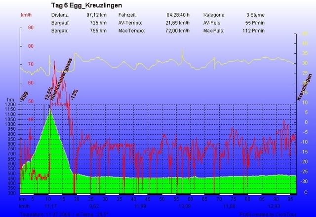
Tag 6 von 6 unserer 5 Ländertour. Heute leider schon der letzte Tag unserer Tour. Auf in Richtung Bodensee. Direkt nach dem Aufsatteln der Anstieg zum Losenpass der ca. 12 Km lang ist. Dort über die Passhöhe gefahren hat man schon den Bodensee in Sicht. Nach einer schönen Abfahrt von leider nur 6 Km befindet man sich schon auf Bodenseehöhe. Über Dornbirn mit einer Pause und Kaffee und Kuchen weiter zum Bodensee und schön in Ufernähe bis Kreuzlingen wo unsere Tour endete. Nach 620 Km und 11.000 Hm kann ich rückblickend sagen das sich die Mühe gelohnt hat. Ich kann diese Route jedem ans Herz legen der eine gewisse Grundkondition mitbringt, die ein oder andere Route kann man sicherlich noch verbessern. Als Ersatzteil bitte Bremsbelege mitnehmen, diese werden gut beansprucht.
Auch hier leider wieder der Hinweis: die Starthöhe in Egg beträgt 544 m. Ich habe mein Collorado 300 jetzt nach einem Update voll im Griff und werde gute Touren weiter einstellen. Für das kommende Jahr haben wir im April Italien/Umbrien geplant um uns einzuradeln für die nächste große Tour die vielleicht durch die französischen Seealpen führt.
Auch hier leider wieder der Hinweis: die Starthöhe in Egg beträgt 544 m. Ich habe mein Collorado 300 jetzt nach einem Update voll im Griff und werde gute Touren weiter einstellen. Für das kommende Jahr haben wir im April Italien/Umbrien geplant um uns einzuradeln für die nächste große Tour die vielleicht durch die französischen Seealpen führt.
Tour gallery
Tour map and elevation profile
Minimum height 1969 m
Maximum height 2616 m
Comments

GPS tracks
Trackpoints-
GPX / Garmin Map Source (gpx) download
-
TCX / Garmin Training Center® (tcx) download
-
CRS / Garmin Training Center® (crs) download
-
Google Earth (kml) download
-
G7ToWin (g7t) download
-
TTQV (trk) download
-
Overlay (ovl) download
-
Fugawi (txt) download
-
Kompass (DAV) Track (tk) download
-
Track data sheet (pdf) download
-
Original file of the author (gpx) download
Add to my favorites
Remove from my favorites
Edit tags
Open track
My score
Rate

