

Start in Krofdorf/Gleiberg unterhalb der Burg Gleiberg im Industriegebiet. Dann geht es sehr lange bergan durch den Wald Richtung Salzböden und anschließend weiter nach Stauffenberg.
Man unterquert die A485 in Richtung Buseck, von da aus über Rödgen Richtung Großen-Buseck und Annerod. Steinbach und Pohlheim/Garbenteich ist das nächste Ziel. Über Linden und Allendorf und Heuchelheim zurück zum Ausgangspunkt.
Further information at
http://www.burg-gleiberg.de/Tour gallery

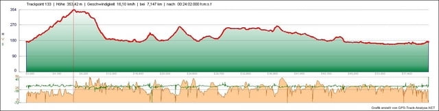
Tour map and elevation profile
Minimum height 157 m
Maximum height 355 m
More about the tour author
|
|
tombbmot |
Comments

GPS tracks
Trackpoints-
GPX / Garmin Map Source (gpx) download
-
TCX / Garmin Training Center® (tcx) download
-
CRS / Garmin Training Center® (crs) download
-
Google Earth (kml) download
-
G7ToWin (g7t) download
-
TTQV (trk) download
-
Overlay (ovl) download
-
Fugawi (txt) download
-
Kompass (DAV) Track (tk) download
-
Track data sheet (pdf) download
-
Original file of the author (gpx) download
More about the tour author
|
|
tombbmot |
Add to my favorites
Remove from my favorites
Edit tags
Open track
My score
Rate