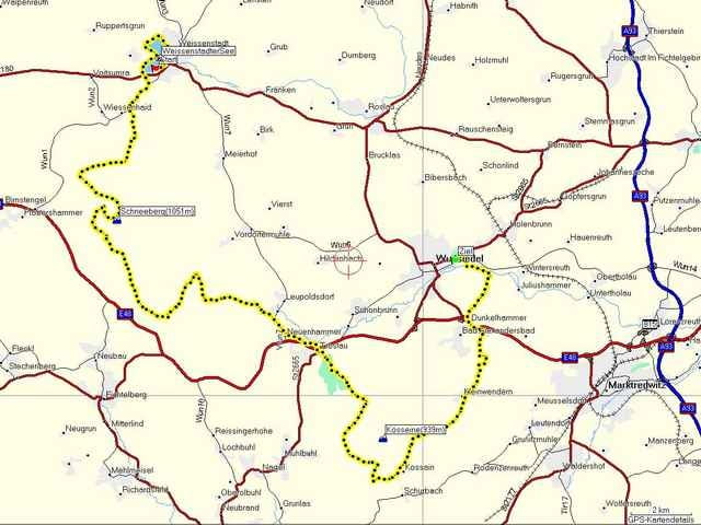
Der Veranstalter beschreibt den Lauf wie folgt:
"Der Fichtelgebirgsmarathon ist ein Landschaftslauf der ganz besonderen Art. Nicht die Bestzeiten stehen hier im Vordergrund, sondern das Lauferlebnis inmitten herrlicher Natur.
Die anspruchsvolle Strecke mit über 800 m Höhenunterschied führt, größtenteils (ca. 80%) auf befestigten Forststraßen und Waldwegen, unter anderem über den höchsten Gipfel des Fichtelgebirges, den Schneeberg.
Es ist ein Lauf durch das Quellgebiet der Flüsse Main, Naab, Saale und Eger und verläuft durch die grünen Wälder unserer Region. Den Teilnehmern bieten sich dabei immer wieder herrliche Panoramablicke über die wildromantische Landschaft."
Start und Ziel liegen ca. 14 km auseinander.
Further information at
http://www.fichtelgebirgsmarathon.deTour gallery
Tour map and elevation profile
Minimum height 522 m
Maximum height 1042 m
Comments

Der Start befindet sich am Weißenstädter See ca. 14 km vom Zielort Wunsidel entfernt. Beide Orte liegen in Oberfranken.
Zum Ziel nach Wunsidel (Bustransfer zum Start):
Von Regensburg aus der A93 bis zur Ausfahrt 13 As Marktretwitz-Nord folgen, dann auf die B303 Richtung Bayreuth abbiegen. Nach 1,5 km rechts nach Wunsidel abzweigen.
Zum Start nach Weißenstadt:
Von Regensburg aus der A93 bis zur Ausfahrt 11 As Thiersheim folgen, dann auf die Landstraße St 2118 nach Weißenstadt abbiegen.
GPS tracks
Trackpoints-
GPX / Garmin Map Source (gpx) download
-
TCX / Garmin Training Center® (tcx) download
-
CRS / Garmin Training Center® (crs) download
-
Google Earth (kml) download
-
G7ToWin (g7t) download
-
TTQV (trk) download
-
Overlay (ovl) download
-
Fugawi (txt) download
-
Kompass (DAV) Track (tk) download
-
Track data sheet (pdf) download
-
Original file of the author (gpx) download
Add to my favorites
Remove from my favorites
Edit tags
Open track
My score
Rate


