Login

Forgotten password?

Cookies have to be accepted!
Your browser's cookie functionality is disabled. Please enable this functionality.

Not a member yet?

Register now
Login

Available for registred users only

Log in to use this feature.

Forgotten password?

Cookies have to be accepted!
Your browser's cookie functionality is disabled. Please enable this functionality.

Not a member yet?

Register now
Filter
Categories
Advanced filters
  • Distance (km)
  • Height
Save filters Reset filter

TrackRank

QRCode

Technical data

Distance5,6 km Height24 m Way down13 m Duration02:00 h:m Date04.10.2009
Scores Author User Landscape Fun factor Fitness Technique

Statistics

5050 Views 2 Scores 165 Downloads 4.50 Average
Rate
  • Track data sheet
  • Directions
  • Downloads

Ruhiger Spaziergang auf kleinen Trampelpfaden, Achtung WURZELN !!

Wenn die Badesaison zu Ende ist, kann man auch wieder an der Isar entlanggehen.

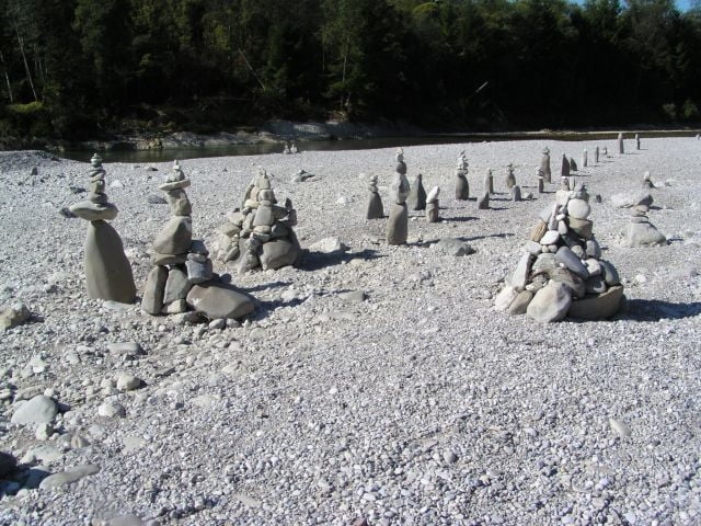
Die Steinmandl bleiben hoffentlich bis zum nächsten Hochwasser stehen, also bitte nicht umschmeißen.

Tour gallery

Tour map and elevation profile

  • Open Street Map
  • Google
Minimum height 575 m Maximum height 592 m Detailed view

More about the tour author

raiwal58
Member since 2009

Send private message

Comments

GPS tracks

Trackpoints
  • GPX / Garmin Map Source (gpx) download
  • TCX / Garmin Training Center® (tcx) download
  • CRS / Garmin Training Center® (crs) download
  • Google Earth (kml) download
  • G7ToWin (g7t) download
  • TTQV (trk) download
  • Overlay (ovl) download
  • Fugawi (txt) download
  • Kompass (DAV) Track (tk) download
  • Track data sheet (pdf) download
  • Original file of the author (gpx) download

More about the tour author

raiwal58
Member since 2009

Send private message
Share track
Add to my favorites
Remove from my favorites
Edit tags
My score
Rate
Track: Pupplinger Au
Type: Hiking
Distance: 5,6 km
Evaluated on:
Duration:
Day(s)
Hour(s)
Minute(s)
Score: Landscape Fun factor Fitness Technique