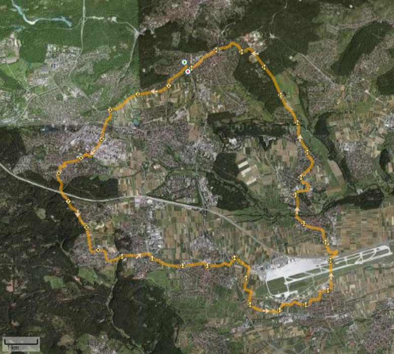
Abendliche 31km Runde von Sonnenberg über Musberg, Flughafen und Fernsehturm.
Vom Ausgangaspunkt Sonnenberg (Haltestelle Peregrinastrasse) ging es über die Streuobstwiesen (Hallenbad Sonnenberg > Vaihingen) nach Vaihingen zum Schulzentrum. Von hier ging es Richtung Industriegebiet und Rohr. In Rohr ging es entlang der Landstrasse den Anstieg nach Oberaichen, Zwischen Oberaichen und Musberg hat man eine genaile Aussicht über die Fildern.
Ab Musberg ging es stetig bergab Richtung Echterdingen / Flughafen. Um nicht den gesamten Flughafen zu umlaufen ging es auf halber Höhe des Flughafen Start-/Landebahn Richtung Plieningen. Von Plieningen ging es über die Uni Hohenheim nach Birkach. Ab Birkach ging es Richtung Schönberg, um entlang der Landstrasse zum Fernsehturm / Waldau Degerloch zu kommen. In Schönberg steht für den Läufe eine kleine aber fiese 15% Steigung bereit. Ab Degerloch / Waldau ging es direkt zum Ausgangspunkt zurück.
Viel Spass beim Nachlaufen!
Happyend
Further information at
http://jog4fun.blogspot.comTour gallery
Tour map and elevation profile
Comments

Ausgangspunkt Sonnenberg / Haltestelle PeregrinaStrasse. Parkplätze gibt es auch nahe am Friedhof / bzw. etwa 500m entfernten Hallenbad Sonnenberg
GPS tracks
Trackpoints-
GPX / Garmin Map Source (gpx) download
-
TCX / Garmin Training Center® (tcx) download
-
CRS / Garmin Training Center® (crs) download
-
Google Earth (kml) download
-
G7ToWin (g7t) download
-
TTQV (trk) download
-
Overlay (ovl) download
-
Fugawi (txt) download
-
Kompass (DAV) Track (tk) download
-
Track data sheet (pdf) download
-
Original file of the author (gpx) download


