Login

Forgotten password?

Cookies have to be accepted!
Your browser's cookie functionality is disabled. Please enable this functionality.

Not a member yet?

Register now
Login

Available for registred users only

Log in to use this feature.

Forgotten password?

Cookies have to be accepted!
Your browser's cookie functionality is disabled. Please enable this functionality.

Not a member yet?

Register now
Filter
Categories
Advanced filters
  • Distance (km)
  • Height
Save filters Reset filter

TrackRank

QRCode

Technical data

Distance23,4 km Height110 m Way down156 m Duration01:50 h:m Date24.09.2010
Scores Author User Landscape Fun factor Fitness Technique

Statistics

1462 Views 2 Scores 222 Downloads 2.50 Average
Rate
  • Track data sheet
  • Directions
  • Downloads


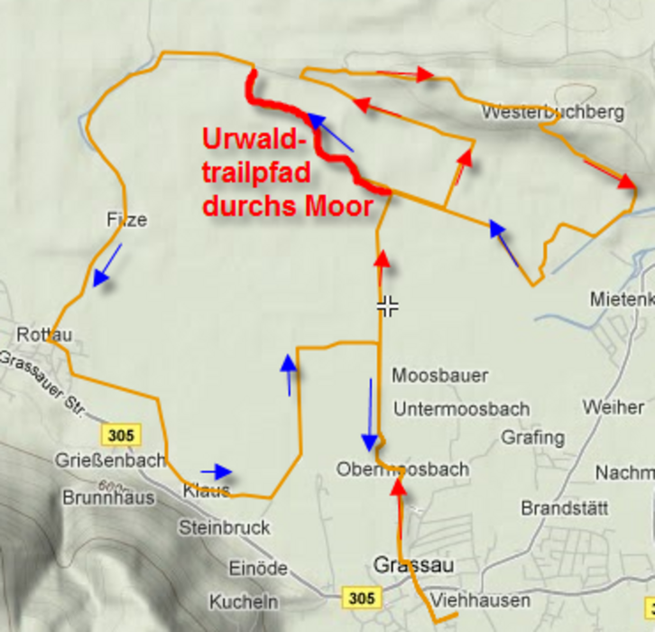
Von Grassau über->  Westerbuchberg -> Mietenkam -> Filze -> Rottau -> Grassau

In der Grafik ist der Routenverlauf mit Pfeilen markiert.
Pfeile nur sichtbar, wenn die Grafik vergrößert wird.

Rot Pfeile     = Hinweg,
Blaue Pfeile = Rückweg

Ab Km 11,7 bis 13,4 = Urwaldtrailpfad durch das Moor!

Tour map and elevation profile

  • Open Street Map
  • Google
Minimum height 526 m Maximum height 602 m Detailed view

More about the tour author

WilliWitzig
Member since 2010

Send private message

Comments

uno on 18.05.2012

Bruchholz

Es liegt viel Bruchholz im Moos. Betrifft die schleife zum Bahnhof und zurück.


Parkplatz = 47° 46' 36.8''
                     12° 27' 19.5''
                     Stadlbauerweg 3
                     83224 Grassau,


GPS tracks

Trackpoints
  • GPX / Garmin Map Source (gpx) download
  • TCX / Garmin Training Center® (tcx) download
  • CRS / Garmin Training Center® (crs) download
  • Google Earth (kml) download
  • G7ToWin (g7t) download
  • TTQV (trk) download
  • Overlay (ovl) download
  • Fugawi (txt) download
  • Kompass (DAV) Track (tk) download
  • Track data sheet (pdf) download
  • Original file of the author (gpx) download

More about the tour author

WilliWitzig
Member since 2010

Send private message
Share track
Add to my favorites
Remove from my favorites
Edit tags
My score
Rate
Track: M4-1, Von Grassau durch die Kendlmühlfilzen
Type: Mountain bike
Distance: 23,4 km
Evaluated on:
Duration:
Day(s)
Hour(s)
Minute(s)
Score: Landscape Fun factor Fitness Technique