
")

Schöne Radtour etwas abseits der Touristenpfade und damit sehr gut auch fürs Wochenende geeignet, wenn die Touristen den Bodenseerundweg verstopfen :-)
Die Tour startet im Ferienpark Immenstaad, führt über Feld-, Rad und wenigbefahrene Straßen durch Äpfelplantagen, kleine Ortschaften an Seen vorbei bis nach Salem Stefansfeld. Dann weiter nach Unteruhldingen und auf dem "Bodenseerundweg" wieder zurück nach Immenstaad.
Die Route wurde mit Kleinkind im Anhänger getrackt, deshalb finden sich ein paar "Ausreisser im Track", sie führen in Stefansfeld zum Bäckerladen (mit sehr gutem und günstigen Kaffee und Kuchen) und in Unteruhldingen ins Grün an der Hafenanlage (Picknic).
Tour gallery
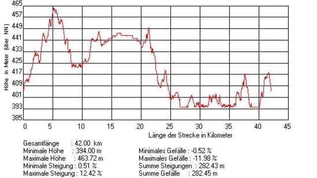
Tour map and elevation profile
Minimum height 396 m
Maximum height 460 m
More about the tour author

|
Comments

GPS tracks
Trackpoints-
GPX / Garmin Map Source (gpx) download
-
TCX / Garmin Training Center® (tcx) download
-
CRS / Garmin Training Center® (crs) download
-
Google Earth (kml) download
-
G7ToWin (g7t) download
-
TTQV (trk) download
-
Overlay (ovl) download
-
Fugawi (txt) download
-
Kompass (DAV) Track (tk) download
-
Track data sheet (pdf) download
-
Original file of the author (gpx) download
More about the tour author
|
|
Add to my favorites
Remove from my favorites
Edit tags
Open track
My score
Rate