Login

Forgotten password?

Cookies have to be accepted!
Your browser's cookie functionality is disabled. Please enable this functionality.

Not a member yet?

Register now
Login

Available for registred users only

Log in to use this feature.

Forgotten password?

Cookies have to be accepted!
Your browser's cookie functionality is disabled. Please enable this functionality.

Not a member yet?

Register now
Filter
Categories
Advanced filters
  • Distance (km)
  • Height
Save filters Reset filter

TrackRank

QRCode

Technical data

Distance78,2 km Height612 m Way down598 m Duration00:00 h:m Date08.08.2007
Scores Author Landscape Fun factor Fitness Technique

Statistics

602 Views Scores 82 Downloads Average
Rate
  • Track data sheet
  • Directions
  • Downloads
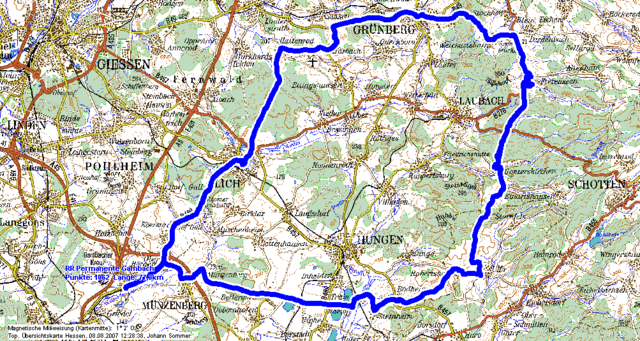
Permanente RTF zum Fusse des Vogelsberg
RV Wanderlust 1912 Gambach

Further information at

http://www.rvw-gambach.de

Tour map and elevation profile

  • Open Street Map
  • Google
Minimum height 130 m Maximum height 332 m Detailed view

More about the tour author

gpstour56

Comments

Start an der Esso Tankstelle in Gambach

GPS tracks

Trackpoints
  • GPX / Garmin Map Source (gpx) download
  • TCX / Garmin Training Center® (tcx) download
  • CRS / Garmin Training Center® (crs) download
  • Google Earth (kml) download
  • G7ToWin (g7t) download
  • TTQV (trk) download
  • Overlay (ovl) download
  • Fugawi (txt) download
  • Kompass (DAV) Track (tk) download
  • Track data sheet (pdf) download
  • Original file of the author (gpx) download

More about the tour author

gpstour56

Share track
Add to my favorites
Remove from my favorites
Edit tags
My score
Rate
Track: Radtourenfahrt zum Fuß des Vogelsberg
Type: Road biking
Distance: 78,2 km
Evaluated on:
Duration:
Day(s)
Hour(s)
Minute(s)
Score: Landscape Fun factor Fitness Technique