

Permanente RTF durchs Lumdatal der RV 1904/27 Gießen Kleinlinden.
Normalerweise startet die Permanente in Giessen bei Fahrrad Fachmarkt Karstadt od. Zweirad Sarges.
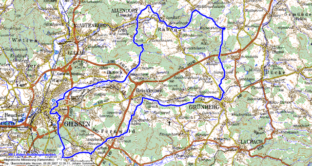
Streckenplan:
Linden-Leihgestern - Watzenborn-Steinberg
Giessen-Wieseck - Hessenradweg R7 nach Trohe
Grossen-Buseck - Beuern - Climbach
Allendorf (Lumda) - Nordeck - Londorf
Kesselbach - Rüddingshausen - Weitershain
Stangenrode - Grünberg - Göbelnrod
Lindenstruth - Burkhardsfelden - Albach
Steinbach - Garbenteich - Leihgestern
Normalerweise startet die Permanente in Giessen bei Fahrrad Fachmarkt Karstadt od. Zweirad Sarges.
Streckenplan:
Linden-Leihgestern - Watzenborn-Steinberg
Giessen-Wieseck - Hessenradweg R7 nach Trohe
Grossen-Buseck - Beuern - Climbach
Allendorf (Lumda) - Nordeck - Londorf
Kesselbach - Rüddingshausen - Weitershain
Stangenrode - Grünberg - Göbelnrod
Lindenstruth - Burkhardsfelden - Albach
Steinbach - Garbenteich - Leihgestern
Further information at
http://www.rv-kleinlinden.deTour map and elevation profile
Minimum height 160 m
Maximum height 352 m
More about the tour author

|
Comments

Startort Bahnhof Grossen Linden
GPS tracks
Trackpoints-
GPX / Garmin Map Source (gpx) download
-
TCX / Garmin Training Center® (tcx) download
-
CRS / Garmin Training Center® (crs) download
-
Google Earth (kml) download
-
G7ToWin (g7t) download
-
TTQV (trk) download
-
Overlay (ovl) download
-
Fugawi (txt) download
-
Kompass (DAV) Track (tk) download
-
Track data sheet (pdf) download
-
Original file of the author (gpx) download
More about the tour author
|
|
Add to my favorites
Remove from my favorites
Edit tags
Open track
My score
Rate