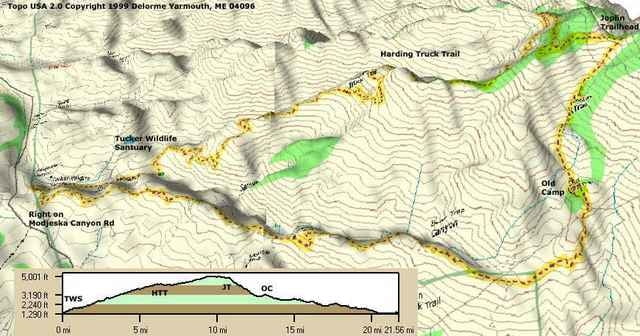
This ride has a number of variations that intermediates would enjoy, as well. The ride starts at the Tucker Wildlife Sanctuary. Head up the Harding Truck Trail fireroad for 9.3 miles and 3000 vertical feet. For a great downhill, you can turn around and go down for a great Intermediate ride. Otherwise, you're not at the top yet. Take a right and go up 2.5 more miles to the singletrack that drops into the canyon. This is Joplin Trail and the most technical part of the ride. Some parts, you may have to walk, but they are few and far between. Once you hit Old Camp, the hardest is over, and you're in for some fast singletrack as a prize for your effort. Stay on the ridgeline, as you're outlining the 4,300 acre canyon on this ride. You'll go straight at all the intersections and come out on Madjesko Canyon Road. Go right, and try to hit 40mph as you head back to the car. Intermediates can also go from Tucker Wildlife Sanctuary up to Old Camp and turn around, for a 15 mile adventure.
Ulteriori informazioni sotto
http://www.raidoh.comMappa itinerario e altimetria
Altezza minima 390 m
Altezza massima 1536 m
Commenti

From the 5 freeway, head east for 10 miles on El Toro Road, right on Madjesko Canyon Road for 2 miles. Park at the Tucker Wildlife Sanctuary.
Tracce GPS
Punti di traccia-
GPX / Garmin Map Source (gpx) download
-
TCX / Garmin Training Center® (tcx) download
-
CRS / Garmin Training Center® (crs) download
-
Google Earth (kml) download
-
G7ToWin (g7t) download
-
TTQV (trk) download
-
Overlay (ovl) download
-
Fugawi (txt) download
-
Kompass (DAV) Track (tk) download
-
Scheda tecnica (pdf) download
-
File originale dell'autore (g7t) download
Aggiungi ai miei preferiti
Rimuovi dai miei preferiti
Modifica dei tag
Tour aperto
Il mio voto
Vota


