


This hike is part of an old Whalers path between Machico and Canical, it is a walk that needs some care as the route seems indistinct in some parts. There are a couple of ridges to cross, the first ridge with a pylon, you climb over and carry on to the next valley, the second ridge you must go around. The path splits just before the second ridge crest and you should carry straight on toward the sea and then follow the path round the ridge crest.
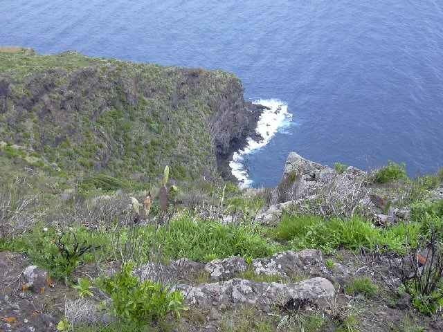
There are terrific views west to Machico, east to Canical, on to the Sao Lourenco Peninsular and over the sea cliffs out to sea.
The walk passes through some ancient derelict terraces, said to be the oldest on the Island.
This hike will always be there but the scenery will alter as Canical now has a new Harbour built for Container ships, it will shortly be an extremely busy industrial area as the working port of Funchal will be moved to Canical.
Galleria itinerari
Mappa itinerario e altimetria
Altezza minima 16 m
Altezza massima 292 m
Maggiori informazioni sull'autore del tour

|
SILVAED |
Commenti

The trailhead starts at the bus stop before the entrance to the Machico / Canical tunnel. This tunnel was one of the first in Madeira. You can get a 113 bus from Funchal to here, there is then a climb via a road up to the Pico do Facho viewpoint and the trail to Canical starts to the left side about 200 meters short of the peak.
The end is at the new church in Canical, where a bus can be taken back to Funchal
The end is at the new church in Canical, where a bus can be taken back to Funchal
Tracce GPS
Punti di traccia-
GPX / Garmin Map Source (gpx) download
-
TCX / Garmin Training Center® (tcx) download
-
CRS / Garmin Training Center® (crs) download
-
Google Earth (kml) download
-
G7ToWin (g7t) download
-
TTQV (trk) download
-
Overlay (ovl) download
-
Fugawi (txt) download
-
Kompass (DAV) Track (tk) download
-
Scheda tecnica (pdf) download
-
File originale dell'autore (g7t) download
Maggiori informazioni sull'autore del tour
|
|
SILVAED |
Aggiungi ai miei preferiti
Rimuovi dai miei preferiti
Modifica dei tag
Tour aperto
Il mio voto
Vota