


We did this walk at the end of October when the leaves were on the turn. We chose this hike for the views over the high Taunus but there is also a good mix of woodland walking too. Plenty of good panaramas but not so many that you get overload.
Just before Niedergladbach the path follows a stream where we saw loads of evidence of wild boar mudbaths. Sadly didn't see one of these very shy (but fierce!) creatures.
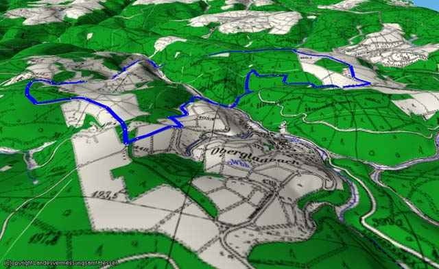
As with all my routes, the Garmin plot is eratic because the etrex does not like the combination of hills and trees too much, so I have provided routes I have corrected by overlaying the track on Magicmaps Hessen 3D.
Applicable map: WM Rheingau Rad- und Wanderkarte 1:40000
Just before Niedergladbach the path follows a stream where we saw loads of evidence of wild boar mudbaths. Sadly didn't see one of these very shy (but fierce!) creatures.
As with all my routes, the Garmin plot is eratic because the etrex does not like the combination of hills and trees too much, so I have provided routes I have corrected by overlaying the track on Magicmaps Hessen 3D.
Applicable map: WM Rheingau Rad- und Wanderkarte 1:40000
Galleria itinerari
Mappa itinerario e altimetria
Altezza minima 219 m
Altezza massima 470 m
Maggiori informazioni sull'autore del tour

|
gpfx |
Commenti

Rainer Jung
on 05.02.2008
Schöne Rundtour, ca. 12 km lang.
There is a good carpark at Roter Kopf, where the route starts, but beware Sunday afternoons when this is a very popular location for some short, circular walks which also start from this car park.
Tracce GPS
Punti di traccia-
GPX / Garmin Map Source (gpx) download
-
TCX / Garmin Training Center® (tcx) download
-
CRS / Garmin Training Center® (crs) download
-
Google Earth (kml) download
-
G7ToWin (g7t) download
-
TTQV (trk) download
-
Overlay (ovl) download
-
Fugawi (txt) download
-
Kompass (DAV) Track (tk) download
-
Scheda tecnica (pdf) download
-
File originale dell'autore (g7t) download
Maggiori informazioni sull'autore del tour
|
|
gpfx |
Aggiungi ai miei preferiti
Rimuovi dai miei preferiti
Modifica dei tag
Tour aperto
Il mio voto
Vota