

This tour is full of landscape contrasts, monuments, forest and seaside as well.
To the people who dont know the area, drive caerfully, specially on the downhills, cause some of then can be a bit technichal. Enjoy as much as you can this tour, because i believe is one of the best ways to see all the area.p.s.s soon the photos will come:]
To the people who dont know the area, drive caerfully, specially on the downhills, cause some of then can be a bit technichal. Enjoy as much as you can this tour, because i believe is one of the best ways to see all the area.p.s.s soon the photos will come:]
Mappa itinerario e altimetria
Altezza minima 7 m
Altezza massima 479 m
Maggiori informazioni sull'autore del tour

|
icon8 |
Commenti
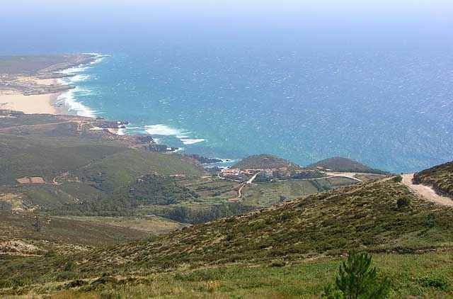
The tour starts in the historical center of Sintra near Quinta da Regaleira, then drive's you thrugh this points Seteais, Capuchos convent, Peninha convent, Azoia, Ulgueira, Praia da Adraga(beach), Praia Grande (beach), Colares, Mucifal, NAffarros, Galamares and back to sintra by Quinta da Regaleira.
Tracce GPS
Punti di traccia-
GPX / Garmin Map Source (gpx) download
-
TCX / Garmin Training Center® (tcx) download
-
CRS / Garmin Training Center® (crs) download
-
Google Earth (kml) download
-
G7ToWin (g7t) download
-
TTQV (trk) download
-
Overlay (ovl) download
-
Fugawi (txt) download
-
Kompass (DAV) Track (tk) download
-
Scheda tecnica (pdf) download
-
File originale dell'autore (g7t) download
Maggiori informazioni sull'autore del tour
|
|
icon8 |
Aggiungi ai miei preferiti
Rimuovi dai miei preferiti
Modifica dei tag
Tour aperto
Il mio voto
Vota
LUI
Nice landscape but ....
Really beautiful landscape and in parts nice ways but you have to walk alot ob this track!
And this is not becouse of minor skills or power. It is just impossible to drive up a way of deep sand...
If you think about doing the track - Do it but think about taking the road uphill to Sintra. The small pathes are not nice to walk up...
And down in the beach i would also recommend the road than the Sand dunes!