


From our stay in Slanders it is still a 45 minutes drive to the valley station of the Meran 2000 area. From here the big gondola takes you quickly up from 650m to 1900m. This is the starting point of our trail, known under the name "Stoanamandl & Knottnkino".
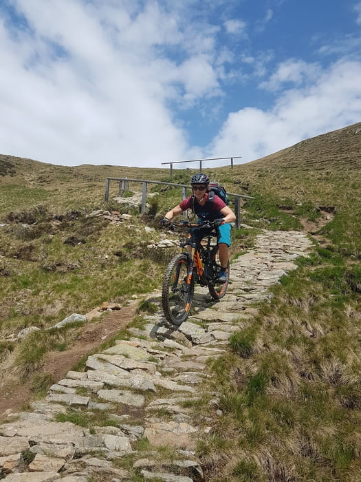
The start is the same as a fairly steep dirt road! Fortunately, it doesn't take long before the climb becomes more even and the first single trail is about to begin. This is fun and easy to ride. We follow this trail to the "Missensteiner Joch" at 2118m. Here we turn right on to a steep single trail down the mountain. This is the first old military road (1st world war) of today. It brings us back to the actual route on the "Kirchsteigeralm" at 1870m. A first Einkehrsmöchlichkeit (restaurant).
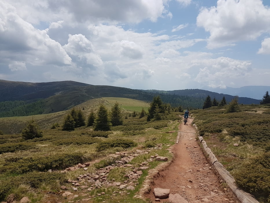
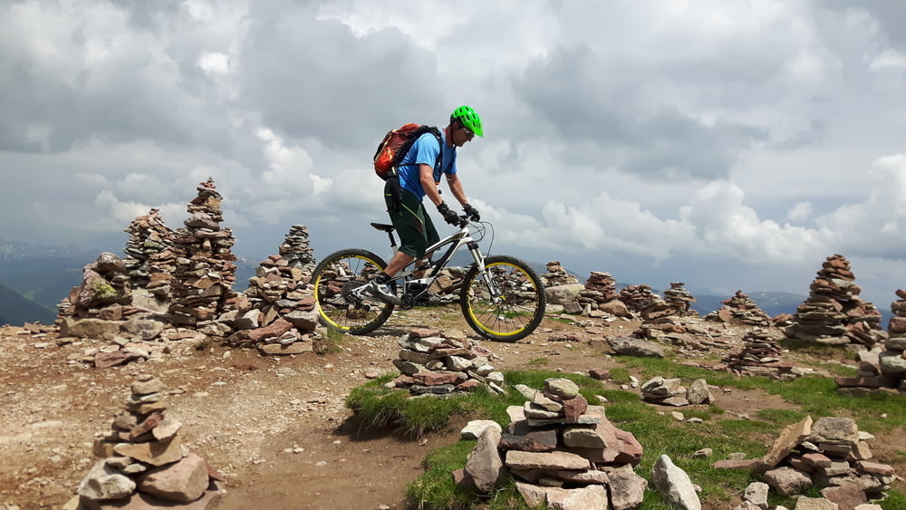
Back on the dirt road we pass the Meraner Hütte (resto) and slowly climb to the next single trail. This doesn't take to long and is one of exceptional beauty. A beautiful rising single trail with steep and technical rock passages surrounded by small trees. It will be around 2000m altitude here. At the top, this trail continues its way over a high mountain plateau, super flowy. With some descents and climbs we pass "Kreuzjoch" at 2084m and continue our way to the "Stoanamandl". The last bit is a pretty steep uphill with some troughs from the last rain fall, hard to ride! Let's try... riding, now and then pushing we reach the top. The very strong mountain goats may stay in the saddle, we had to walk a few times. At the top you understand immediately why the trail is called "Stoanamandl"! It is not surprising that this was a Celtic cult place in ancient times.
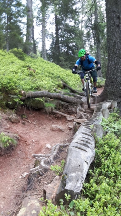
This aswell the beginning of the trail which will leads us back to the bottom station at 650m. It starts with a flow trail through a meadow and then changes into a loose rock path that ends with another "Einkehrmöchlichkeit". Here we turn right onto a dirt road to the right and after 150m again to the right into a small meadow. Through the small meadow we arrive at a gate in the fence... this is the start of a heavy single dh trail! The trail changes between wider path, dirt roads, more single trail and some tarmac. It's about here that you will be at 1300m and will get to the "Vöranerstrasse" coming from the "Oberhauserknott". STOP with the GPX and FOLLOW the WRITTEN INSTRUCTIONS. Turn right at the house onto the "Vöranerstrasse" and paddle a 150 meters uphill till you get to the entrance of the single trail 12A. Follow this trail till you enter the main road LS98. Follow the gpx again. This is the only little bit of asphalt road with traffic. Be carefull, ride behind eachother in the direction of Hafling. Through the tunnel (you can skip as well) over the bridge and to left, Have an ice cream there. On the right side you see the bike route. Take this road and turn into the single trail a bit further. This is a start of an other old military road. It's steep and can be slippery at times, but is lots of fun as well. This will bring you back to the main road a while further down which leads you to the parking.
Single trails S0 - S3
All in all a super day and a super trail. An absolute must do...
The start is the same as a fairly steep dirt road! Fortunately, it doesn't take long before the climb becomes more even and the first single trail is about to begin. This is fun and easy to ride. We follow this trail to the "Missensteiner Joch" at 2118m. Here we turn right on to a steep single trail down the mountain. This is the first old military road (1st world war) of today. It brings us back to the actual route on the "Kirchsteigeralm" at 1870m. A first Einkehrsmöchlichkeit (restaurant).
Back on the dirt road we pass the Meraner Hütte (resto) and slowly climb to the next single trail. This doesn't take to long and is one of exceptional beauty. A beautiful rising single trail with steep and technical rock passages surrounded by small trees. It will be around 2000m altitude here. At the top, this trail continues its way over a high mountain plateau, super flowy. With some descents and climbs we pass "Kreuzjoch" at 2084m and continue our way to the "Stoanamandl". The last bit is a pretty steep uphill with some troughs from the last rain fall, hard to ride! Let's try... riding, now and then pushing we reach the top. The very strong mountain goats may stay in the saddle, we had to walk a few times. At the top you understand immediately why the trail is called "Stoanamandl"! It is not surprising that this was a Celtic cult place in ancient times.
This aswell the beginning of the trail which will leads us back to the bottom station at 650m. It starts with a flow trail through a meadow and then changes into a loose rock path that ends with another "Einkehrmöchlichkeit". Here we turn right onto a dirt road to the right and after 150m again to the right into a small meadow. Through the small meadow we arrive at a gate in the fence... this is the start of a heavy single dh trail! The trail changes between wider path, dirt roads, more single trail and some tarmac. It's about here that you will be at 1300m and will get to the "Vöranerstrasse" coming from the "Oberhauserknott". STOP with the GPX and FOLLOW the WRITTEN INSTRUCTIONS. Turn right at the house onto the "Vöranerstrasse" and paddle a 150 meters uphill till you get to the entrance of the single trail 12A. Follow this trail till you enter the main road LS98. Follow the gpx again. This is the only little bit of asphalt road with traffic. Be carefull, ride behind eachother in the direction of Hafling. Through the tunnel (you can skip as well) over the bridge and to left, Have an ice cream there. On the right side you see the bike route. Take this road and turn into the single trail a bit further. This is a start of an other old military road. It's steep and can be slippery at times, but is lots of fun as well. This will bring you back to the main road a while further down which leads you to the parking.
Single trails S0 - S3
All in all a super day and a super trail. An absolute must do...
Galleria itinerari
Mappa itinerario e altimetria
Altezza minima 627 m
Altezza massima 2116 m
Maggiori informazioni sull'autore del tour
|
|
Kanski |
Commenti
Tracce GPS
Punti di traccia-
GPX / Garmin Map Source (gpx) download
-
TCX / Garmin Training Center® (tcx) download
-
CRS / Garmin Training Center® (crs) download
-
Google Earth (kml) download
-
G7ToWin (g7t) download
-
TTQV (trk) download
-
Overlay (ovl) download
-
Fugawi (txt) download
-
Kompass (DAV) Track (tk) download
-
Scheda tecnica (pdf) download
-
File originale dell'autore (gpx) download
Maggiori informazioni sull'autore del tour
|
|
Kanski |
Aggiungi ai miei preferiti
Rimuovi dai miei preferiti
Modifica dei tag
Tour aperto
Il mio voto
Vota
Tour
super genauer gps-track - vielen dank!!