
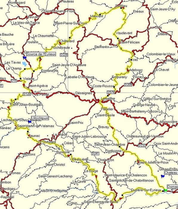

This route takes you through the northern part of the Ardeche. From the town Saint-Laurent-Du-Pape it runs north to Lamastre and St-Félicien. Near Lalouvesc has been a big forestfire a few years ago. The route continues southeast. Slightly north of St-Agrève is the location of the source of the rivier Eyrieux. It is not possible to follow the first few kilometres of this river, but after the town Intres the road sticks to the river. The route follows this river all the way down to the starting point of this route. The river runs only a few kilomtres further and ends in the Rhone near the town Beauchastel.
---
Deze mooie route loopt door het noorden van de Ardeche. Vanaf Saint-Laurent-du-Pape begint de route met een klim richting Vernoux-En-Vivarais. Dan via Lamastre en St-Félicien verder noordwaarts. In de buurt van Lalouvesc is een paar jaar terug een felle bosbrand geweest. Van hieruit rijdt u zuidoostwaarts om iets ten noorden van St-Agrève bij de bron van de rivier de Eyrieux te komen. Het eerste stuk van deze rivier is niet constant te volgen op de motor, maar vanaf Intres houdt de weg vast aan de rivier. U volgt nu de rivier dan ook helemaal tot aan Domaine de l’Amiral! De Eyrieux mondt slechts 5 kilometer verder, bij Beauchastel, uit in de Rhone.
---
Op www.motorrijden.fr kunt u deze track ook als route downloaden.
Ulteriori informazioni sotto
http://www.motorrijden.frMappa itinerario e altimetria
Altezza minima 99999 m
Altezza massima -99999 m
Maggiori informazioni sull'autore del tour

|
Rambling_man |
Commenti

Tracce GPS
Punti di traccia-
GPX / Garmin Map Source (gpx) download
-
TCX / Garmin Training Center® (tcx) download
-
CRS / Garmin Training Center® (crs) download
-
Google Earth (kml) download
-
G7ToWin (g7t) download
-
TTQV (trk) download
-
Overlay (ovl) download
-
Fugawi (txt) download
-
Kompass (DAV) Track (tk) download
-
Scheda tecnica (pdf) download
-
File originale dell'autore (gpx) download
Maggiori informazioni sull'autore del tour
|
|
Rambling_man |
Aggiungi ai miei preferiti
Rimuovi dai miei preferiti
Modifica dei tag
Tour aperto
Il mio voto
Vota