Accesso

Hai dimenticato il login?

I cookie devono essere accettati!
La funzione cookie del suo browser è disattivata. Si prega di attivare la funzione.

Non sei ancora membro?

Registrati ora
Accesso

Possibile solo per gli utenti registrati

Effettua il login per poter utilizzare questa funzione.

Hai dimenticato il login?

I cookie devono essere accettati!
La funzione cookie del suo browser è disattivata. Si prega di attivare la funzione.

Non sei ancora membro?

Registrati ora
Filtro
Categorie
Filtri avanzati
  • Lunghezza (km)
  • Dislivello
Memorizza filtro Azzera il filtro

TrackRank

QRCode

Dati tecnici

Lunghezza70,7 km Dislivello481 m Discesa482 m Durata01:50 h:m Data07.01.2009
Valutazioni Autore Paesaggio Divertimento Condizione Tecnica

Statistica

785 Visualizzazioni Valutazioni 24 Download Media
Vota
  • Scheda tecnica
  • Come arrivare
  • Download

The Ironman Langkawi track (one loop) as it was to be ridden from 2007 onwards. In 2009 there will be a new track!

3 loops were to be ridden, the first 10km and the last 6km of this track are the in and out parts to complete the 180km.

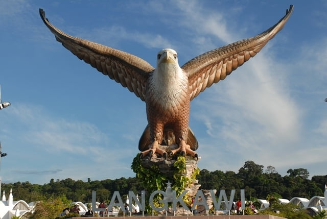
The track is pretty straight forward, starting at the Kuah Jetty at the huge eagle statue, then towards the city heading to the police station and then approx 5km on a steep up and down "highway" (2x 10%).

The main part of the loop consists of everything but straights! Be ready for windy, hot and humid conditions. 3 times to ride btw "Thai restaurant", the airport and the Tanjung Rhu beach.

Galleria itinerari

Mappa itinerario e altimetria

  • Open Street Map
  • Google
Altezza minima -4 m Altezza massima 75 m Vista dettagliata

Maggiori informazioni sull'autore del tour

mblanarik
Membro dal 2006

Invia un messaggio privato

Commenti

...once you got to Malaysia, you can either fly to Langkawi or take a ferry from Penang, Kuala Kedah or Kuala Perlis.

Alternatively you can fly in from Singapore or Thailand.


Tracce GPS

Punti di traccia
  • GPX / Garmin Map Source (gpx) download
  • TCX / Garmin Training Center® (tcx) download
  • CRS / Garmin Training Center® (crs) download
  • Google Earth (kml) download
  • G7ToWin (g7t) download
  • TTQV (trk) download
  • Overlay (ovl) download
  • Fugawi (txt) download
  • Kompass (DAV) Track (tk) download
  • Scheda tecnica (pdf) download
  • File originale dell'autore (gpx) download

Maggiori informazioni sull'autore del tour

mblanarik
Membro dal 2006

Invia un messaggio privato
Share track
Aggiungi ai miei preferiti
Rimuovi dai miei preferiti
Modifica dei tag
Il mio voto
Vota
Itinerario: Ironman Malaysia Langkawi
Tipo: Bicicletta da corsa
Lunghezza: 70,7 km
Valutato su:
Durata:
Giorni/Diurni
Ora/Ore
Minuti
Valutazione: Paesaggio Divertimento Condizione Tecnica