Scroll down for English.
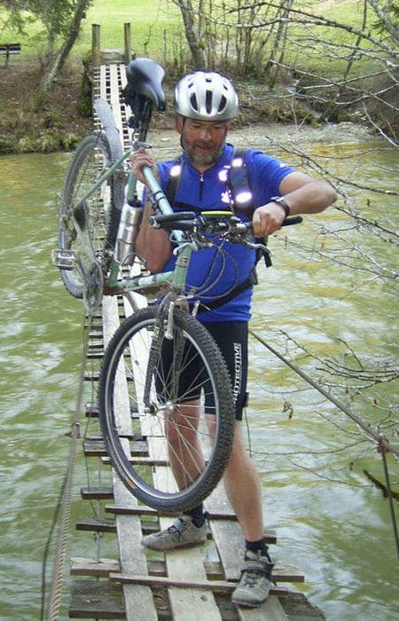
Hier handelt es sich um eine meiner Lieblings-Kurztouren. Zuerst radeln Sie Richtung Wertachtal und weiter auf abgelegenen Wegen durch Bachtel und Wildberg. Kurz nach Wildberg kommen sie zu einer Hängebrücke. Schon das Überqueren der Brücke ist ein Abenteuer für sich. Es wackelt und schaukelt, der Fluß nur wenige Meter unter Ihnen, während Sie Ihr Fahrrad hinüber schieben oder tragen. Gleich nach der Überquerung finden Sie den perfekten Platz für eine kurze Pause.
Nach dem Aufstieg aus dem Wertachtal folgen Sie einem Fahrradweg nach Rückholz und anschließend über landwirtschaftliche Wege wieder ins Wertachtal und weiter nach Nesselwang.
This is one of my favourite short tours (23 kms) from Nesselwang.
Dropping down to and then crossing the Wertach River you follow tracks and little used roads through Bachtel and Wildberg to reach a hanging bridge which takes you back across the Wertach.
The bridge itself is an adventure as it shakes and rolls below you while you carry your bike across. On the far side is a field with a seat to enjoy a rest and maybe something to drink and eat.
Once you have climbed out of the valley there is a cycle track most of the way back to Rückholz where you turn off back on to side roads. You finish by dropping back down in to the Wertach Valley and then following a side valley back to Nesselwang.
Ulteriori informazioni sotto
http://www.hogarth.de/index.php?article_id=133Mappa itinerario e altimetria
Altezza minima 798 m
Altezza massima 932 m
Commenti
Startpunkt ist bei Jons Adventures (www.jons-adventures.com) in Nesselwang.
Hier können Sie sowohl Fahrrad, als auch GPS Receiver ausleihen.
Start at Jons Adventures in Nesselwang (www.jons-adventures.com)
Here you can also hire a bike and / or GPS receiver if necessary.
Hier können Sie sowohl Fahrrad, als auch GPS Receiver ausleihen.
Start at Jons Adventures in Nesselwang (www.jons-adventures.com)
Here you can also hire a bike and / or GPS receiver if necessary.
Tracce GPS
Punti di traccia-
GPX / Garmin Map Source (gpx) download
-
TCX / Garmin Training Center® (tcx) download
-
CRS / Garmin Training Center® (crs) download
-
Google Earth (kml) download
-
G7ToWin (g7t) download
-
TTQV (trk) download
-
Overlay (ovl) download
-
Fugawi (txt) download
-
Kompass (DAV) Track (tk) download
-
Scheda tecnica (pdf) download
Aggiungi ai miei preferiti
Rimuovi dai miei preferiti
Modifica dei tag
Tour aperto
Il mio voto
Vota


Sehr schön
Biketour
Vielen Dank dafür. Gruss von ritl2021.
Suspension Bridge
Wir sind heute die Tour gefahren, mit Kindern und Tandem-Kinderrad.
War echt super und hat riesig Spaß gemacht, wobei die Brücke die Krönung von der Tour war wo es auch noch was fürs zweite Hobby gab.
Mit den Kinder konnten wir auch gut fahren, da es kaum öffentliche Straßen gab Bd wenn war da wenig Verkehr.
Ich kann die Tour mit gutem Gewissen weiter Empfehlen.
Danke für die schöne Tour, die wir so sicher nicht gefunden hätten.
Viele Grüße
Landsucher