
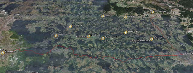

102km long, 1,500 vertical meters. The first 25km are only on the roads (from Vilseck to Amberg), so you could skip that part and simply start in Amberg (thanks Bernd).
The last half of the tour is the best part. The trail is marked well (blue line on white square), and is fairly easy to follow. The last 40km are challanging and tons of fun. There are some crazy trails around the Nurnberg Zoo. Once you get to Nurnberg, ride to the Hauptbahnhof and catch a train back (Bayern pass is like 20 euro for 4 people).
Even better, grab a few beers at the Mexican restaurant (Enchiladas) in the main square, then catch the train.
Plan for a LONG day though, as you'll slow down a bit as you hit the last 40km.
-------------------------------------------------------
102km lang. 1,500hm. Erste 25km sind nur strassen (von Vilseck bis Amberg) und sind nicht ein emphelenswert teil des Tour. Die letze halb des Tour ist die Schonsten. Es ist gut markiert (blau linie markierung) and meistens einfach su folgen. Letze 40km sind anspruchsvoll und spass. Alles vor ist ein bisschen langweilig aber nicht schlect.
Galleria itinerari

Mappa itinerario e altimetria
Altezza minima 304 m
Altezza massima 637 m
Maggiori informazioni sull'autore del tour
|
|
adamschlang |
Commenti

Amberg Zentrum oder Nurnberg Tiergarten (biden rechnung moeglich)
Tracce GPS
Punti di traccia-
GPX / Garmin Map Source (gpx) download
-
TCX / Garmin Training Center® (tcx) download
-
CRS / Garmin Training Center® (crs) download
-
Google Earth (kml) download
-
G7ToWin (g7t) download
-
TTQV (trk) download
-
Overlay (ovl) download
-
Fugawi (txt) download
-
Kompass (DAV) Track (tk) download
-
Scheda tecnica (pdf) download
-
File originale dell'autore (gpx) download
Maggiori informazioni sull'autore del tour
|
|
adamschlang |
Aggiungi ai miei preferiti
Rimuovi dai miei preferiti
Modifica dei tag
Tour aperto
Il mio voto
Vota