Inloggen

Login vergeten?

Cookies moeten worden aanvaard!
De cookiefunctie van uw browser is gedeactiveerd. Activeer de functie.

Ben je nog geen lid?

Registreer nu
Inloggen

Alleen mogelijk voor ingelogde gebruikers

Log in om deze functie te kunnen gebruiken.

Login vergeten?

Cookies moeten worden aanvaard!
De cookiefunctie van uw browser is gedeactiveerd. Activeer de functie.

Ben je nog geen lid?

Registreer nu
Filter
Categorieën
Geavanceerde filters
  • Lengte (km)
  • Hoogtemeter
Filter opslaan Filter resetten

TrackRank

QRCode

Technische gegevens

Lengte8,3 km Hoogtemeter448 m Afdaling510 m Duur03:00 h:m Datum29.06.2015
Beoordelingen Auteur Landschap Funfactor Conditie Techniek

Statistiek

689 Views Beoordelingen 22 Downloads Gemiddelde
Tarief
  • Pagina van de tocht
  • Route
  • Downloads

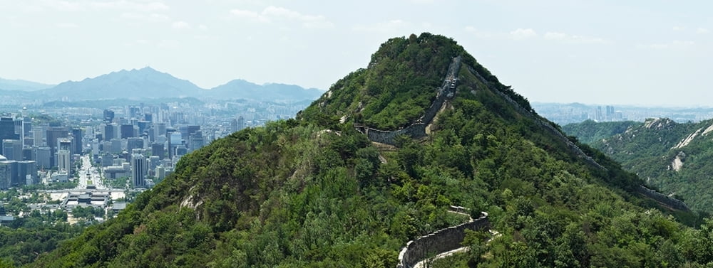
Fantastic tour along a part of the ancient city wall of Seoul. Great views onto the city its sights and the surroundings.

The trail starts at Waryong park. Be sure you have your passport with you, because you need to register for the section between Malbawi Information Center and Changuimun Gate.

You come along the beautiful heights of Baegak mountain and Inwangsan mountain with fantastic views on the whole city and Gyeongbokgung Palace, Blue House, Namsan Tower and many other sights.

For more information go to: seoulcitywall.seoul.go.kr/front/eng/index.do


Verdere informatie onder

https://en.wikipedia.org/wiki/Seoul

Fotogalerie van de tocht

Kaart en hoogteprofiel van de tocht

  • Open Street Map
  • Google
Minimumhoogte 97 m Maximale hoogte 387 m Detailweergave

Meer over de tour auteur

grenz-pfad-fahrer
Lid sinds 2009

Stuur een privébericht

Commentaren

Take subway number 3 to Anguk station, then take bus number 2 to the final stop, where the track starts.

The track ends at Dongnimmun station; line number 3.


GPS-tracks

Trackpoints
  • GPX / Garmin Map Source (gpx) download
  • TCX / Garmin Training Center® (tcx) download
  • CRS / Garmin Training Center® (crs) download
  • Google Earth (kml) download
  • G7ToWin (g7t) download
  • TTQV (trk) download
  • Overlay (ovl) download
  • Fugawi (txt) download
  • Kompass (DAV) Track (tk) download
  • Pagina van de tocht (pdf) download
  • Origineel dossier van de auteur (gpx) download

Meer over de tour auteur

grenz-pfad-fahrer
Lid sinds 2009

Stuur een privébericht
Share track
Toevoegen aan mijn favorieten
Uit mijn favorieten verwijderen
Tags bewerken
Mijn waardering
Tarief
Tocht: Seoul City Wall - Baegak and Inwangsan mountain
Type: Wandelen
Lengte: 8,3 km
Evaluated on:
Duur:
Dagen
Uurtjes
Minuten
Beoordeling: Landschap Funfactor Conditie Techniek