

Als aanvulling op de tocht geef ik nog even de route naar de Ferry in (Kingston upon) Hull. Van daaruit vaar je naar Rotterdam Europoort (NL) of Zeebrugge (B). Wie naar Newcastle terug wil kan de National cycle Route 1 volgen in Noordelijke richting. De route vind je hier: http://www.sustrans.org.uk/ncn/map/route/route-1
Карта маршрута и высотный профиль
Minimum height 99999 m
Maximum height -99999 m
More about the tour author

|
partnair |
Комментарии

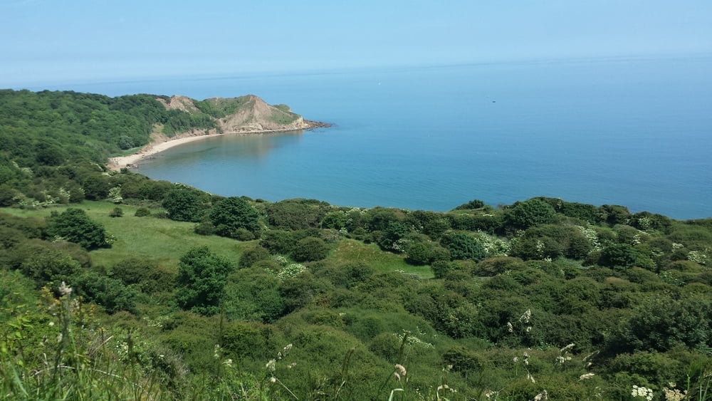
De tocht begint in Robin Hoods bay (dorp) en gaat over een redelijk ruig pad heel mild omhoog.
Geniet van de prachtige Noordzeekust.
Tussenstop op de camping van east end farm even na Driffield. Eevoudige boerencamping met een leuke uitbater.
as addition I give you the route to the Ferry in Hull. The boats sail to Rotterdam Europoort (NL) and Zeebrugge (B). Who wants to go back to Newcastle can folow the National Cycle Route 1 in Northern direction. You can find the Route here:http://www.sustrans.org.uk/ncn/map/route/route-1
The track starts in the village of Robin Hoods bay and go gently up over a rough path.
Enjoy the beautiful view on the Northsea coast.
Stopover on the campsite East end farm after Driffield. This is a simple Farm campsite with a lovely owner.
GPS-Tracks
Trackpoints-
GPX / Garmin Map Source (gpx) download
-
TCX / Garmin Training Center® (tcx) download
-
CRS / Garmin Training Center® (crs) download
-
Google Earth (kml) download
-
G7ToWin (g7t) download
-
TTQV (trk) download
-
Overlay (ovl) download
-
Fugawi (txt) download
-
Kompass (DAV) Track (tk) download
-
Формуляр маршрута (pdf) download
-
Original file of the author (gpx) download
More about the tour author
|
|
partnair |
Add to my favorites
Remove from my favorites
Edit tags
Open track
My score
Rate