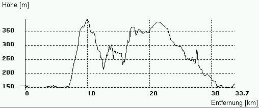
Diese technisch einfache Tour beinhaldet zwei steile Anstiege, welche allerdings auf breiten Schotterwegen abgefahren werden. Die Tour ist mit zwei kleinen Trails gespikt. Einer führt dabei von Nennsdorf in Richtung Ammerbach und der andere wartet am Ende der Tour, von Carl-August in Richtung Jena, auf seine Befahrung. Dazu sollte allerdings auf dem Weg, welcher rechts parallel zum Radweg entlang führt, gefahren werden.
Viel Spaß beim Nachfahren.
Карта маршрута и высотный профиль
Minimum height 146 m
Maximum height 391 m
Комментарии

GPS-Tracks
Trackpoints-
GPX / Garmin Map Source (gpx) download
-
TCX / Garmin Training Center® (tcx) download
-
CRS / Garmin Training Center® (crs) download
-
Google Earth (kml) download
-
G7ToWin (g7t) download
-
TTQV (trk) download
-
Overlay (ovl) download
-
Fugawi (txt) download
-
Kompass (DAV) Track (tk) download
-
Формуляр маршрута (pdf) download
-
Original file of the author (gpx) download
Add to my favorites
Remove from my favorites
Edit tags
Open track
My score
Rate

