Login

Забыл пароль?

Cookies have to be accepted!
Your browser's cookie functionality is disabled. Please enable this functionality.

Not a member yet?

Register now
Login

Available for registred users only

Log in to use this feature.

Забыл пароль?

Cookies have to be accepted!
Your browser's cookie functionality is disabled. Please enable this functionality.

Not a member yet?

Register now
Filter
Категории
Advanced filters
  • Длина (км)
  • Высотомер
Сохранить фильтр Reset filter

TrackRank

QRCode

Technical data

Длина17,5 km Высотомер678 m Way down m Длительность02:00 h:m Дата15.04.2004
Оценки Author Ландшафт Веселье Кондиция Техника

Статистика

3546 Виды Оценки 411 Загрузки Среднее
Rate
  • Формуляр маршрута
  • Дорога
  • Загрузки
Kurze Runde mit einigen steilen Auffahrten.
Beliebig erweiterbar.

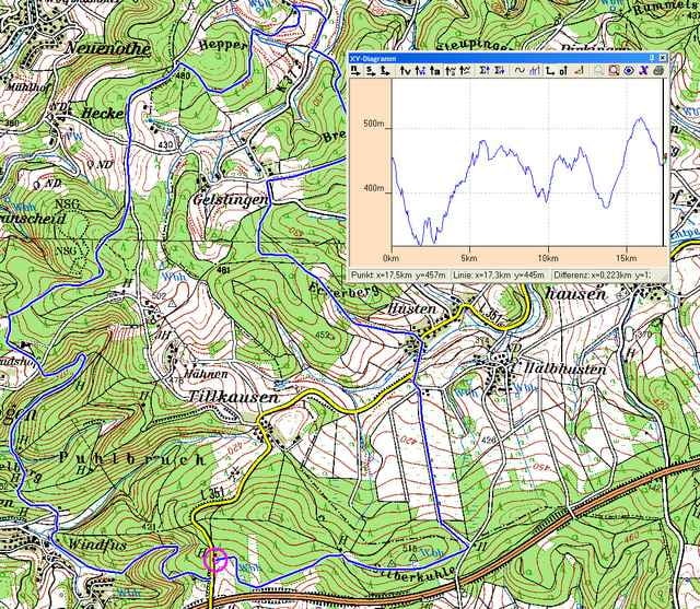
Карта маршрута и высотный профиль

  • Open Street Map
  • Google
Minimum height 316 m Maximum height 515 m Детальный вид

More about the tour author

abusch

Комментарии

A4 Abfahrt 27 (Eckenhagen). Richtung Blockhaus-Hespert. Über die Autobahnbrücke. Parken rechts auf dem Wanderparkplatz (Tourende)

GPS-Tracks

Trackpoints
  • GPX / Garmin Map Source (gpx) download
  • TCX / Garmin Training Center® (tcx) download
  • CRS / Garmin Training Center® (crs) download
  • Google Earth (kml) download
  • G7ToWin (g7t) download
  • TTQV (trk) download
  • Overlay (ovl) download
  • Fugawi (txt) download
  • Kompass (DAV) Track (tk) download
  • Формуляр маршрута (pdf) download
  • Original file of the author (g7t) download

More about the tour author

abusch

Share track
Add to my favorites
Remove from my favorites
Edit tags
My score
Rate
Маршрут: Silberkuhle
Вид: Горный велосипед
Длина: 17,5 km
Evaluated on:
Длительность:
Day(s)
Hour(s)
Minute(s)
Оценка: Ландшафт Веселье Кондиция Техника