Login

Забыл пароль?

Cookies have to be accepted!
Your browser's cookie functionality is disabled. Please enable this functionality.

Not a member yet?

Register now
Login

Available for registred users only

Log in to use this feature.

Забыл пароль?

Cookies have to be accepted!
Your browser's cookie functionality is disabled. Please enable this functionality.

Not a member yet?

Register now
Filter
Категории
Advanced filters
  • Длина (км)
  • Высотомер
Сохранить фильтр Reset filter

TrackRank

QRCode

Technical data

Длина14,0 km Высотомер205 m Way down207 m Длительность01:10 h:m Дата06.10.2009
Оценки Author Ландшафт Веселье Кондиция Техника

Статистика

1229 Виды Оценки 34 Загрузки Среднее
Rate
  • Формуляр маршрута
  • Дорога
  • Загрузки
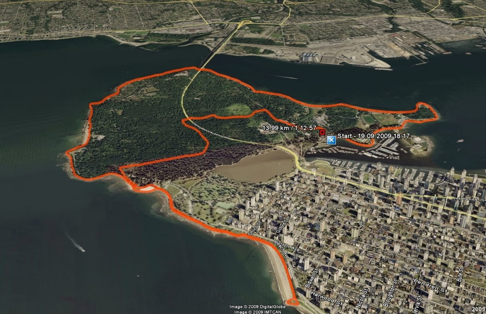
Die Strecke führt erst einmal entlang des Seawall um den Stanley Park und nach dem Wende Punkt ging quer durch den Park (landschaftlich ein Highlight) zurück zum Ausgangspunkt.

Further information at

http://www.360cities.net/image/stanly-park-viewing-downtown-vancouver-dusk-canada

Галерея маршрутов

Карта маршрута и высотный профиль

  • Open Street Map
  • Google
Minimum height -16 m Maximum height 37 m Детальный вид

More about the tour author

happyend
Member since 2009

Send private message

Комментарии

Parkplatz nahe am Row Club Vancouver

GPS-Tracks

Trackpoints
  • GPX / Garmin Map Source (gpx) download
  • TCX / Garmin Training Center® (tcx) download
  • CRS / Garmin Training Center® (crs) download
  • Google Earth (kml) download
  • G7ToWin (g7t) download
  • TTQV (trk) download
  • Overlay (ovl) download
  • Fugawi (txt) download
  • Kompass (DAV) Track (tk) download
  • Формуляр маршрута (pdf) download
  • Original file of the author (gpx) download

More about the tour author

happyend
Member since 2009

Send private message
Share track
Add to my favorites
Remove from my favorites
Edit tags
My score
Rate
Маршрут: Stanley Park - Vancouver
Вид: Бег
Длина: 14,0 km
Evaluated on:
Длительность:
Day(s)
Hour(s)
Minute(s)
Оценка: Ландшафт Веселье Кондиция Техника