Login

Забыл пароль?

Cookies have to be accepted!
Your browser's cookie functionality is disabled. Please enable this functionality.

Not a member yet?

Register now
Login

Available for registred users only

Log in to use this feature.

Забыл пароль?

Cookies have to be accepted!
Your browser's cookie functionality is disabled. Please enable this functionality.

Not a member yet?

Register now
Filter
Категории
Advanced filters
  • Длина (км)
  • Высотомер
Сохранить фильтр Reset filter

TrackRank

QRCode

Technical data

Длина96,5 km Высотомер3937 m Way down3926 m Длительность1 day 18 h Дата06.11.2009
Оценки Author User Ландшафт Веселье Кондиция Техника

Статистика

2327 Виды 1 Оценка 462 Загрузки 5.00 Среднее
Rate
  • Формуляр маршрута
  • Дорога
  • Загрузки

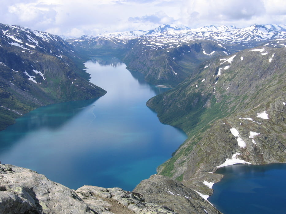
In 6 Tagen von Hütte zu Hütte  durch duch den Nationalpark Jotunheimen.Von Spiterstulen können Norwegens höchste Berge bestiegen werden. (Galthoppigen,Glittertind)


9

Галерея маршрутов

Карта маршрута и высотный профиль

  • Open Street Map
  • Google
Minimum height 964 m Maximum height 1756 m Детальный вид

More about the tour author

akirapp
Member since 2008

Send private message

Комментарии

DNT Hütte Gjendesheim

GPS-Tracks

Trackpoints
  • GPX / Garmin Map Source (gpx) download
  • TCX / Garmin Training Center® (tcx) download
  • CRS / Garmin Training Center® (crs) download
  • Google Earth (kml) download
  • G7ToWin (g7t) download
  • TTQV (trk) download
  • Overlay (ovl) download
  • Fugawi (txt) download
  • Kompass (DAV) Track (tk) download
  • Формуляр маршрута (pdf) download
  • Original file of the author (gpx) download

More about the tour author

akirapp
Member since 2008

Send private message
Share track
Add to my favorites
Remove from my favorites
Edit tags
My score
Rate
Маршрут: Jotunheimen
Вид: Пешеходный туризм
Длина: 96,5 km
Evaluated on:
Длительность:
Day(s)
Hour(s)
Minute(s)
Оценка: Ландшафт Веселье Кондиция Техника