Login

Забыл пароль?

Cookies have to be accepted!
Your browser's cookie functionality is disabled. Please enable this functionality.

Not a member yet?

Register now
Login

Available for registred users only

Log in to use this feature.

Забыл пароль?

Cookies have to be accepted!
Your browser's cookie functionality is disabled. Please enable this functionality.

Not a member yet?

Register now
Filter
Категории
Advanced filters
  • Длина (км)
  • Высотомер
Сохранить фильтр Reset filter

TrackRank

QRCode

Technical data

Длина178,0 km Высотомер3235 m Way down3453 m Длительность14:00 h:m Дата23.08.2010
Оценки Author Ландшафт Веселье Кондиция Техника

Статистика

2949 Виды 2 Оценки 221 Загрузки 4.00 Среднее
Rate
  • Формуляр маршрута
  • Дорога
  • Загрузки

http://de.wikipedia.org/wiki/Rennsteig

Further information at

http://de.wikipedia.org/wiki/Rennsteig

Галерея маршрутов

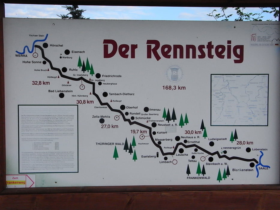
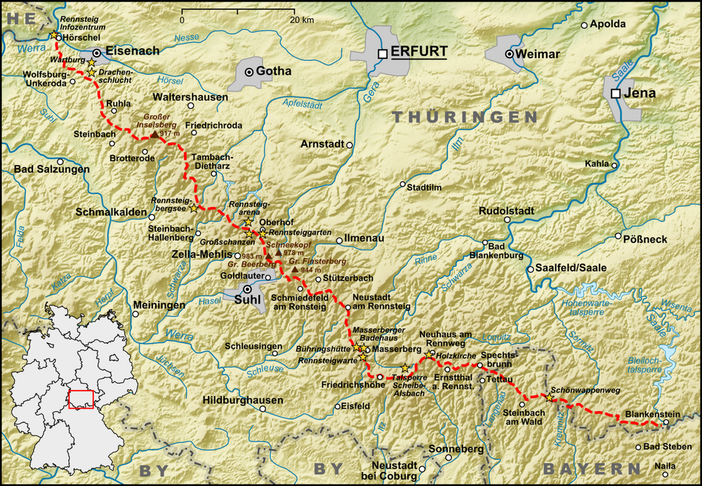
Карта маршрута и высотный профиль

  • Open Street Map
  • Google
Minimum height 203 m Maximum height 969 m Детальный вид

More about the tour author

winklem
Member since 2005

Send private message

Комментарии

Anfahrt nach Blankenstein und mit dem Zug über Erfurt von Hörschel wieder zurück

GPS-Tracks

Trackpoints
  • GPX / Garmin Map Source (gpx) download
  • TCX / Garmin Training Center® (tcx) download
  • CRS / Garmin Training Center® (crs) download
  • Google Earth (kml) download
  • G7ToWin (g7t) download
  • TTQV (trk) download
  • Overlay (ovl) download
  • Fugawi (txt) download
  • Kompass (DAV) Track (tk) download
  • Формуляр маршрута (pdf) download
  • Original file of the author (gpx) download

More about the tour author

winklem
Member since 2005

Send private message
Share track
Add to my favorites
Remove from my favorites
Edit tags
My score
Rate
Маршрут: 2 Tagestour Rennsteig von Blankenstein nach Hörschel
Вид: Горный велосипед
Длина: 178,0 km
Evaluated on:
Длительность:
Day(s)
Hour(s)
Minute(s)
Оценка: Ландшафт Веселье Кондиция Техника