
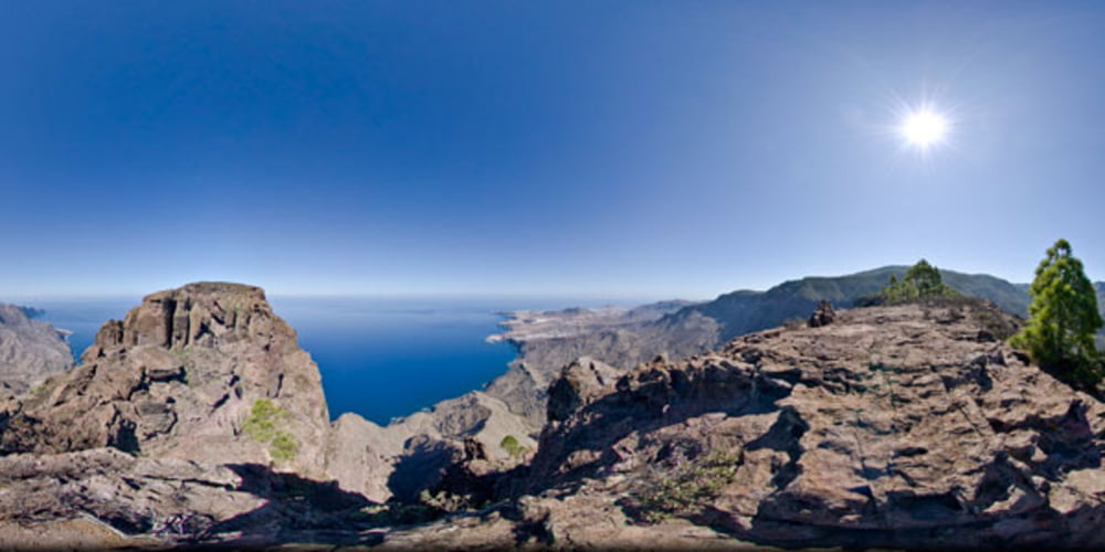

Ruta de montaña (alta montaña)exigente campo a traves, sin camino hasta el roque faneque,tamadaba y vuelta al risco.Paisage espectacular y vistas que quitan el aliento.
Ir bien equipados,botas,ropa tecnica,agua y vitualla.Recomendable cuerda,cintas expres y arneses.(para el paso del gigante)paso expuesto,equipado con algunas chapas.
Cuidado si llueve o esta humedo el suelo.
Галерея маршрутов


Карта маршрута и высотный профиль
Minimum height 183 m
Maximum height 1045 m
More about the tour author
|
|
madeheimclaudio |
Комментарии
Salida desde el risco hasta final de la carretera asfaltada,para subir por una ladera hasta una degollada que ofrece unas fantasticas vistas.Una vez alli se crestea y trepa hasta llegar al roque faneque donde podremos disfrutar si esta despejado de unas fantasticas vistas.Sa baja por la vertiente oriental para llegar al paso del gigante.Paso expuesto bastante peligroso (Mejor asegurarse).Una vez pasado el paso se sube por la ladera occidental para cojer un camino que nos lleva de nuevo al risco.
GPS-Tracks
Trackpoints-
GPX / Garmin Map Source (gpx) download
-
TCX / Garmin Training Center® (tcx) download
-
CRS / Garmin Training Center® (crs) download
-
Google Earth (kml) download
-
G7ToWin (g7t) download
-
TTQV (trk) download
-
Overlay (ovl) download
-
Fugawi (txt) download
-
Kompass (DAV) Track (tk) download
-
Формуляр маршрута (pdf) download
-
Original file of the author (tcx) download
More about the tour author
|
|
madeheimclaudio |
Add to my favorites
Remove from my favorites
Edit tags
Open track
My score
Rate
#73302: ruta risco-faneque-risco