Login

Забыл пароль?

Cookies have to be accepted!
Your browser's cookie functionality is disabled. Please enable this functionality.

Not a member yet?

Register now
Login

Available for registred users only

Log in to use this feature.

Забыл пароль?

Cookies have to be accepted!
Your browser's cookie functionality is disabled. Please enable this functionality.

Not a member yet?

Register now
Filter
Категории
Advanced filters
  • Длина (км)
  • Высотомер
Сохранить фильтр Reset filter

TrackRank

QRCode

Technical data

Длина3,2 km Высотомер708 m Way down13 m Длительность00:00 h:m Дата30.05.2011
Оценки Author Ландшафт Веселье Кондиция Техника

Статистика

243 Виды Оценки 16 Загрузки Среднее
Rate
  • Формуляр маршрута
  • Дорога
  • Загрузки
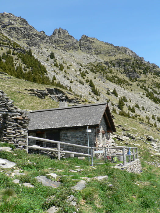
Lasciata l'auto in località Fontana, (Val Pontirone)si prende il segnalato ed erto sentiero che prima attraverso alpeggi e quindi un fitto bosco di conifere in circa due ore porta al Rifugio Biasagn,(incustodito)da dove si gode una bellissima vista. Il ritorno si effettua per il medesimo sentiero.

Галерея маршрутов

Карта маршрута и высотный профиль

  • Open Street Map
  • Google
Minimum height 1312 m Maximum height 2019 m Детальный вид

More about the tour author

gcasti
Member since 2009

Send private message

Комментарии

GPS-Tracks

Trackpoints
  • GPX / Garmin Map Source (gpx) download
  • TCX / Garmin Training Center® (tcx) download
  • CRS / Garmin Training Center® (crs) download
  • Google Earth (kml) download
  • G7ToWin (g7t) download
  • TTQV (trk) download
  • Overlay (ovl) download
  • Fugawi (txt) download
  • Kompass (DAV) Track (tk) download
  • Формуляр маршрута (pdf) download
  • Original file of the author (gpx) download

More about the tour author

gcasti
Member since 2009

Send private message
Share track
Add to my favorites
Remove from my favorites
Edit tags
My score
Rate
Маршрут: Rifugio Biasagn 30 maggio 2011
Вид: Пешеходный туризм
Длина: 3,2 km
Evaluated on:
Длительность:
Day(s)
Hour(s)
Minute(s)
Оценка: Ландшафт Веселье Кондиция Техника