

Offizielle Mountainbikeroute Nr. 4 von Appenzellerland Tourismus AI.
Wunderschöne Tour durchs Appenzellerland.
Verpflegen kann man sich im Gasthaus Bären (www.baeran-schlatt.ch) oder im Gasthaus Leimensteig (www.gasthaus-leimensteig.ch).
Geführte Touren - Bike mieten - Bikeurlaub in Appenzell:
http://www.bike-appenzellerland.ch
GPS-Touren in der Schweiz:
http://www.gps-touren.ch
GPS-Daten in beliebiges Format konvertieren:
http://www.gpsies.com/upload.do?uploadMode=convert
Further information at
http://www.bike-appenzellerland.chКарта маршрута и высотный профиль
Minimum height 99999 m
Maximum height -99999 m
More about the tour author

|
jeki |
Комментарии

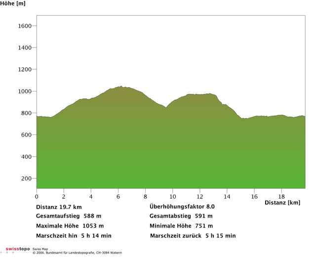
Tourstart ist beim Brauereiplatz in Appenzell.
GPS-Tracks
Trackpoints-
GPX / Garmin Map Source (gpx) download
-
TCX / Garmin Training Center® (tcx) download
-
CRS / Garmin Training Center® (crs) download
-
Google Earth (kml) download
-
G7ToWin (g7t) download
-
TTQV (trk) download
-
Overlay (ovl) download
-
Fugawi (txt) download
-
Kompass (DAV) Track (tk) download
-
Формуляр маршрута (pdf) download
-
Original file of the author (gpx) download
More about the tour author
|
|
jeki |
Add to my favorites
Remove from my favorites
Edit tags
Open track
My score
Rate