Login

Zabudli ste prihlasovacia meno

Cookies have to be accepted!
Your browser's cookie functionality is disabled. Please enable this functionality.

Not a member yet?

Register now
Login

Available for registred users only

Log in to use this feature.

Zabudli ste prihlasovacia meno

Cookies have to be accepted!
Your browser's cookie functionality is disabled. Please enable this functionality.

Not a member yet?

Register now
Filter
Kategórie
Advanced filters
  • Dĺžka (km)
  • výškomer
Uložiť filter Reset filter

TrackRank

QRCode

Technical data

Dĺžka28,9 km výškomer297 m Way down325 m Doba01:30 h:m dátum05.05.2005
ohodnotenia Author Kraj pôžitok z túry kondícia technika

štatistika

1613 náhľady ohodnotenia 581 Stiahnutia priemer
Rate
  • list trasy
  • príjazd
  • Stiahnutia
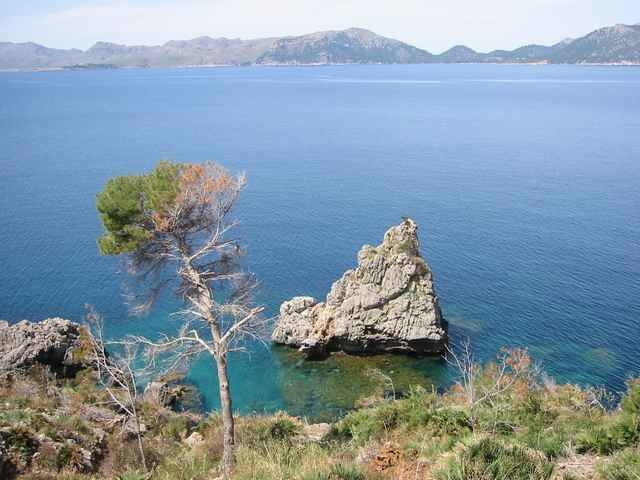
Diese Tour ist lanschaftlich sehr reizvoll und als kleine "Spazierfahrt" zur Regeneration ideal. Leider kommt man nicht bis ans Ende des Caps weil dort militärisches Sperrgebiet ist.

Further information at

http://www.huerzeler.com

Mapa trasy a výškový profil

  • Open Street Map
  • Google
Minimum height 1 m Maximum height 143 m Detailný pohľad

More about the tour author

larstragl

komentáre

GPS trasy

Trackpoints
  • GPX / Garmin Map Source (gpx) download
  • TCX / Garmin Training Center® (tcx) download
  • CRS / Garmin Training Center® (crs) download
  • Google Earth (kml) download
  • G7ToWin (g7t) download
  • TTQV (trk) download
  • Overlay (ovl) download
  • Fugawi (txt) download
  • Kompass (DAV) Track (tk) download
  • list trasy (pdf) download
  • Original file of the author (g7t) download

More about the tour author

larstragl

Share track
Add to my favorites
Remove from my favorites
Edit tags
My score
Rate
trasa: Cap Pinar
Druh: pretekársky bicykel
Dĺžka: 28,9 km
Evaluated on:
Doba:
Day(s)
Hour(s)
Minute(s)
ohodnotenie: Kraj pôžitok z túry kondícia technika