


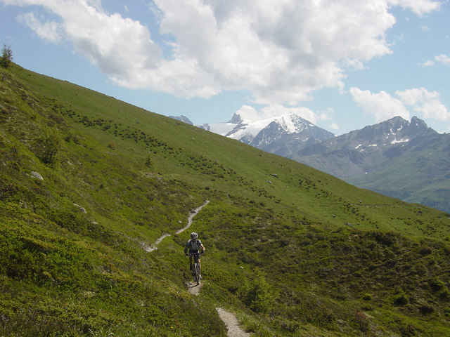
Die start ist von parking Chalais, Seilbahn => Vercorin. Sie machen ein aufsteige auf Waldweg von 1300 bis 2100m. Nachher, es gibt ein wunderbar singletrack und Waldweg. Nach 1km nehmen Sie im rechts ein Wanderweg. Es gibt ein kleine Trage. Sie folgen auf Strasse/Waldweg bis Bendolla. Sie folgen diese Waldweg bis 2400meter. Nachher es ist ein Wanderweg mit viele Trage bis 2600 meter. Es gibt ein wunderbar Alm. Sie machen ein Austiege bis pas de lona. HOPP !!! nehmen die Abfahrte von pas de lona umgekehrt und Maurice Zermatten Wanderweg. Sie folgen immer single track auf Alm. Es gibt ein kleine Aufstiege bis 2300 und die wunderbar final Abfahrten bis 500meter 90% auf Single track!!!
Nehmen die Strasse bis Chalais Seilbahn parking
Nehmen die Strasse bis Chalais Seilbahn parking
galéria trás
Mapa trasy a výškový profil
Minimum height 554 m
Maximum height 2837 m
More about the tour author

|
preusser |
komentáre
GPS trasy
Trackpoints-
GPX / Garmin Map Source (gpx) download
-
TCX / Garmin Training Center® (tcx) download
-
CRS / Garmin Training Center® (crs) download
-
Google Earth (kml) download
-
G7ToWin (g7t) download
-
TTQV (trk) download
-
Overlay (ovl) download
-
Fugawi (txt) download
-
Kompass (DAV) Track (tk) download
-
list trasy (pdf) download
-
Original file of the author (gpx) download
More about the tour author
|
|
preusser |
Add to my favorites
Remove from my favorites
Edit tags
Open track
My score
Rate
Tourerlebnis Lona