

Meine Wanderung startet an den Koordinaten N47 48 14.1 E16 00 57.7.
An der Abzweigung in die Forststraße gibt es zwar nicht viele Parkplätze, aber ich finde Platz und es ist einmal ein neuer Startpunkt für mich.
Ich folge dem beschilderten Weg Richtung Wilhlem-Eichert Hütte. Dann passiere ich die Abzweigung zum "Seiser Toni" (ehemaliges Gasthaus. Parkmöglichkeiten). Da ich aber eine kleine Schleife gehen will, halte ich mich links und folge dem Wanderweg weiter.
In einem großen Halbbogen komme ich etwas später zum "Seiser Toni" und halte mich ein kurzes Stück auf der asphaltierten Straße rechts.
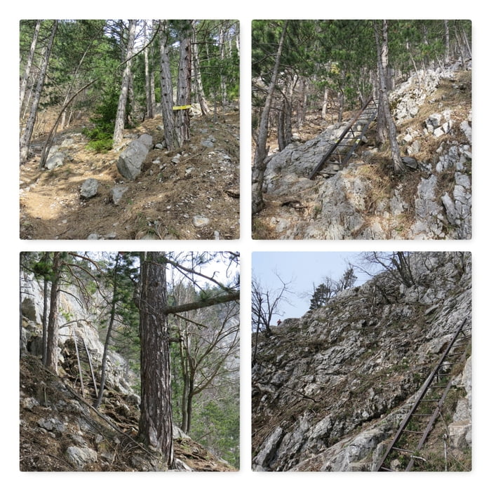
Nach wenigen hundert Metern finde ich die Abzweigung zum Wagnersteig.
Der Wagnersteig (A) ist zu Beginn ein steiler Wanderweg, erst gegen Ende kommen einige kurze, aber einfache Leitern und einige mit Stahlseil gesicherte Stellen.
Further information at
http://www.volki.at/cgi-bin/wegtab.pl?B=hw&Z=WAMapa trasy a výškový profil
Minimum height 728 m
Maximum height 1012 m
More about the tour author
|
|
huberj59 |
komentáre

Parkplatz: N47 48 14.1 E16 00 57.7.
GPS trasy
Trackpoints-
GPX / Garmin Map Source (gpx) download
-
TCX / Garmin Training Center® (tcx) download
-
CRS / Garmin Training Center® (crs) download
-
Google Earth (kml) download
-
G7ToWin (g7t) download
-
TTQV (trk) download
-
Overlay (ovl) download
-
Fugawi (txt) download
-
Kompass (DAV) Track (tk) download
-
list trasy (pdf) download
-
Original file of the author (gpx) download
More about the tour author
|
|
huberj59 |
Add to my favorites
Remove from my favorites
Edit tags
Open track
My score
Rate