

Die Wanderung startet an den Koordinaten N48° 19' 07.6" E16° 14' 17.0".
Als Erstes gehen wir zur Heilquelle (hilft bei Augenleiden; man muss die Augen benetzen...) und füllen unsere Wasserflaschen an. Siehe Link.
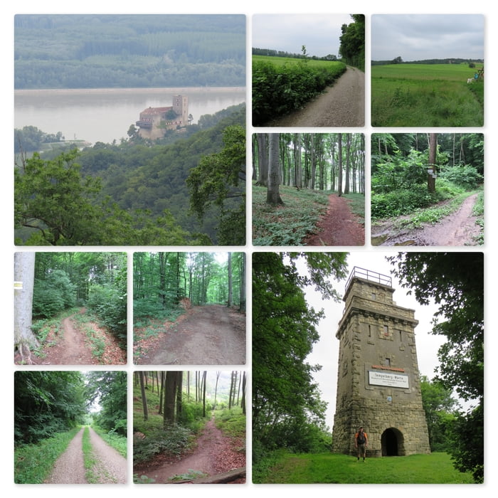
Nun folgen wir dem Rundweg der uns zu aller erst einmal au fen Binderjockl hinauf führt. Es geht durch den Wald (Kaufmais) bis zum großen Feld vor Hadersfeld.
Wir queren das Feld und gehen über die Schlossgasse zur Tempelbergwarte: https://de.wikipedia.org/wiki/Tempelbergwarte
Der Aussichtsturm gibt eine wunderbare Fernsicht auf die Donau und die Burg Greifenstein.
Nach einer kleinen Pause gehen wir den gleichen Weg zurück nach Hadersfeld und dann beim Schloss rechts am Rehgehege und dem Köbering vorbei zum Schneiderzipf.
Am Schneiderzipf angekommen biegen wir links ab und kommen alsbald wieder zur Lourdesgrotte zurück.
Further information at
https://de.wikipedia.org/wiki/Lourdesgrotte_im_WienerwaldMapa trasy a výškový profil
Minimum height 260 m
Maximum height 413 m
More about the tour author
|
|
huberj59 |
komentáre

Parkplatz bei der Lourdesgrotte: N48° 19' 07.6" E16° 14' 17.0"
GPS trasy
Trackpoints-
GPX / Garmin Map Source (gpx) download
-
TCX / Garmin Training Center® (tcx) download
-
CRS / Garmin Training Center® (crs) download
-
Google Earth (kml) download
-
G7ToWin (g7t) download
-
TTQV (trk) download
-
Overlay (ovl) download
-
Fugawi (txt) download
-
Kompass (DAV) Track (tk) download
-
list trasy (pdf) download
-
Original file of the author (gpx) download
More about the tour author
|
|
huberj59 |
Add to my favorites
Remove from my favorites
Edit tags
Open track
My score
Rate