
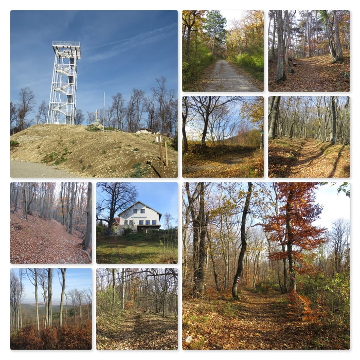

Meine Wanderung beginnt am Gut Richardhof.
Ich folge der geschotterten Foststraße in den Wald. Vor dem Wohnhaus zweigt der Wanderweg linkerhand ab und umrundet das Haus.
Anschließend nehme ich die linke Abzweigung und folge dem Wanderweg bergan.
Ich gehe am Sender vorbei (links oben) und stehe alsbald vor dem Anninger Schutzhaus.
Rechts am Schutzhaus vorbei geht es zur neuen Jubiläumswarte. Unmittelbar dahinter führt meine Wanderung weiter bis ich zur großen Anninger Schotterstraße komme. Ich gehe diese bergab bis zur alten Rodelbahn und folge dem Trail ein kurzes Stück bergauf bis ich wieder auf den Wanderweg stoße.
Nun halte ich mich auf dem Wanderweg. Nach einer kurzen Weile wechsle ich den Wanderweg bergab und umrunde den Golfplatz bis ich wieder bei meinem Parkplatz angekommen bin.
Further information at
http://www.anningerhaus.at/ueber_uns/Mapa trasy a výškový profil
Minimum height 320 m
Maximum height 652 m
More about the tour author
|
|
huberj59 |
komentáre

Parkplatz am Richardhof, Koordinaten: N48° 03' 17.3" E16° 16' 29.2"
GPS trasy
Trackpoints-
GPX / Garmin Map Source (gpx) download
-
TCX / Garmin Training Center® (tcx) download
-
CRS / Garmin Training Center® (crs) download
-
Google Earth (kml) download
-
G7ToWin (g7t) download
-
TTQV (trk) download
-
Overlay (ovl) download
-
Fugawi (txt) download
-
Kompass (DAV) Track (tk) download
-
list trasy (pdf) download
-
Original file of the author (gpx) download
More about the tour author
|
|
huberj59 |
Add to my favorites
Remove from my favorites
Edit tags
Open track
My score
Rate