

Etzelwang in Bayern hat einen eigenen Bahnhof (VGN-Haltepunkt) und einen Campingplatz. In Pommelsbrunn (an der B14) befindet sich ein Gasthaus, in dessen Garten eine weit ausladende, 300 Jahre alte Linde zur Rast einlädt. Das Gasthaus "Zum Schwarzen Brand" in Heuchling hat nur manchmal geöffnet.
galéria trás
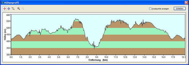
Mapa trasy a výškový profil
Minimum height 99999 m
Maximum height -99999 m
More about the tour author

|
pippin_44 |
komentáre

Mit dem Auto:
Von Sulzbach-Rosenberg (B14) über Neukirchen nach Etzelwang
oder: BAB 9-Ausfahrt Hersbruck (auf B14) in Richtung Sulzbach-Rosenberg; in Weigendorf links abbiegen.
Mit der Bahn:
Nürnberg-Hauptbahnhof, Regionalbahn nach Neukirchen b. Sulzbach-Rosenberg/Schwandorf); am Haltepunkt Etzelwang aussteigen.
GPS trasy
Trackpoints-
GPX / Garmin Map Source (gpx) download
-
TCX / Garmin Training Center® (tcx) download
-
CRS / Garmin Training Center® (crs) download
-
Google Earth (kml) download
-
G7ToWin (g7t) download
-
TTQV (trk) download
-
Overlay (ovl) download
-
Fugawi (txt) download
-
Kompass (DAV) Track (tk) download
-
list trasy (pdf) download
-
Original file of the author (gpx) download
More about the tour author
|
|
pippin_44 |
Add to my favorites
Remove from my favorites
Edit tags
Open track
My score
Rate