Login

Zabudli ste prihlasovacia meno

Cookies have to be accepted!
Your browser's cookie functionality is disabled. Please enable this functionality.

Not a member yet?

Register now
Login

Available for registred users only

Log in to use this feature.

Zabudli ste prihlasovacia meno

Cookies have to be accepted!
Your browser's cookie functionality is disabled. Please enable this functionality.

Not a member yet?

Register now
Filter
Kategórie
Advanced filters
  • Dĺžka (km)
  • výškomer
Uložiť filter Reset filter

TrackRank

QRCode

Technical data

Dĺžka83,8 km výškomer1795 m Way down1796 m Doba05:05 h:m dátum03.07.2008
ohodnotenia Author Kraj pôžitok z túry kondícia technika

štatistika

1235 náhľady ohodnotenia 231 Stiahnutia priemer
Rate
  • list trasy
  • príjazd
  • Stiahnutia

Streckenführung: Rundkurs um Albstadt. Forst- und Waldwege, asphaltierte Straßen.


1. Verpflegungstation: Raichberg bei ca. 34 km
2. Verpflegungstation nach Burgfelderstaige bei ca. 56 km
3. Verpflegungstation Lerchenfeld bei ca. 72 km


Further information at

http://www.albstadtbikemarathon.de/pdf2008/bikemarathon.pdf

galéria trás

Mapa trasy a výškový profil

  • Open Street Map
  • Google
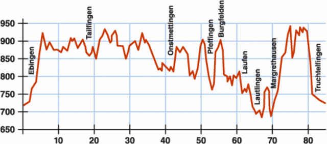
Minimum height 677 m Maximum height 952 m Detailný pohľad

More about the tour author

HASA1965
Member since 2008

Send private message

komentáre

Start/Ziel:

Schmiechastraße in Albstadt-Ebingen

GPS trasy

Trackpoints
  • GPX / Garmin Map Source (gpx) download
  • TCX / Garmin Training Center® (tcx) download
  • CRS / Garmin Training Center® (crs) download
  • Google Earth (kml) download
  • G7ToWin (g7t) download
  • TTQV (trk) download
  • Overlay (ovl) download
  • Fugawi (txt) download
  • Kompass (DAV) Track (tk) download
  • list trasy (pdf) download
  • Original file of the author (gpx) download

More about the tour author

HASA1965
Member since 2008

Send private message
Share track
Add to my favorites
Remove from my favorites
Edit tags
My score
Rate
trasa: Albstadt-LBS Bike Marathon 2007, (Update 28.06.08)
Druh: horský bicykel
Dĺžka: 83,8 km
Evaluated on:
Doba:
Day(s)
Hour(s)
Minute(s)
ohodnotenie: Kraj pôžitok z túry kondícia technika