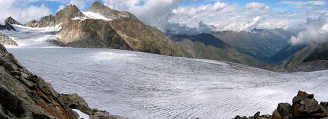
Rundtour. Weg anfangs wie zur Rinnenspitze. Der "Umweg" ueber die Reste des Rinnenspitzferners (Steigeisen ratsam) ist nicht zwingend noetig, wer will kann auch direkt zum Innenren Rinnennieder aufsteigen. Dadurch erspart man sich das Tragen der Steigeisen und einiges grobes Blockwerk zwischendurch...
Trackfile copyright under Creative Commons (By attribution, share alike). See: http://creativecommons.org/licenses/by-sa/2.5/
Karte: DAV 31/2 (Stubaier Alpen / Sellarin)
Trackfile copyright under Creative Commons (By attribution, share alike). See: http://creativecommons.org/licenses/by-sa/2.5/
Karte: DAV 31/2 (Stubaier Alpen / Sellarin)
Mapa trasy a výškový profil
Minimum height 2142 m
Maximum height 2885 m
komentáre

Franz Senn Huette, 2147m, http://www.franzsennhuette.at
Aufstieg siehe Tour 2110: "Aufstieg zur Franz Senn Huette"
Anfahrt: Innsbruck, Brenner-Autobahn, Abfahrt Stubaital. Dann nach Neustift, Milders, Sedugg, Obberiesalm.
Aufstieg siehe Tour 2110: "Aufstieg zur Franz Senn Huette"
Anfahrt: Innsbruck, Brenner-Autobahn, Abfahrt Stubaital. Dann nach Neustift, Milders, Sedugg, Obberiesalm.
GPS trasy
Trackpoints-
GPX / Garmin Map Source (gpx) download
-
TCX / Garmin Training Center® (tcx) download
-
CRS / Garmin Training Center® (crs) download
-
Google Earth (kml) download
-
G7ToWin (g7t) download
-
TTQV (trk) download
-
Overlay (ovl) download
-
Fugawi (txt) download
-
Kompass (DAV) Track (tk) download
-
list trasy (pdf) download
-
Original file of the author (g7t) download
Add to my favorites
Remove from my favorites
Edit tags
Open track
My score
Rate


