


Klettersteig Westliche und östliche Latemartürme.
Track aufgezeichnet am 29.06.2008 mit Garmin etrex Vista hcx.
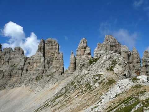
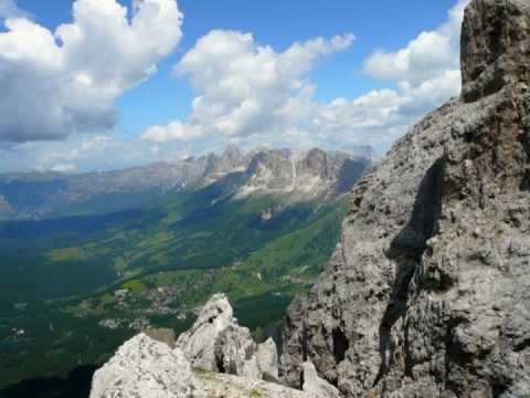
Impressionen als Diashow:
Optimale Qualität mit der Option "in hoher Qualität ansehen" rechts unter dem youtub-video-fenster.
- Impressionen vom Klettersteig: www.youtube.com/watch
- Panoramaansichten der Umgebung: www.youtube.com/watch
Start und Ziel: Bergstation Sessellift Obereggen, erreichbar von Obereggen.
Verlauf:
Von dort aus auf Weg 18 / 516 über Gamsstall-Scharte Richtung Rothlahnscharte --> Einstieg in den Klettersteig --> bis Große Latemarscharte (Biwak-Hütte E. Rigatti). Von dort weiter unten am Hang zurück auf Weg 18 bis zum Einstiegspunkt und dann auf gleichem Weg zurück zur Bergstation.
Alle Streckenlängen und Höhenmeter netto ohne Seilbahnfahrt.
Zeitangaben mit Seilbahnfahrt und Pausen.
Bei guter Sicht grandiose Aussichten!
Ich habe über You-Tube eine kurze Diashow mit Panoramabildern als Appetitanreger drangehängt. Die Wiedergabequalität ist zwar eher mäßig aber besser als nix - oder?
Internetlinks:
Latemar: de.wikipedia.org/wiki/Latemar
Obereggen: www.obereggen.com/
Karerpass: de.wikipedia.org/wiki/Karerpass
galéria trás


Mapa trasy a výškový profil
Minimum height 1941 m
Maximum height 2755 m
More about the tour author
|
|
Andreas_H |
komentáre

Brennerautobahn (A22), Ausfahrt Bozen Nord, S241 Richtung Karerpass bis Birchabruck, dann Richtung Obereggen
GPS trasy
Trackpoints-
GPX / Garmin Map Source (gpx) download
-
TCX / Garmin Training Center® (tcx) download
-
CRS / Garmin Training Center® (crs) download
-
Google Earth (kml) download
-
G7ToWin (g7t) download
-
TTQV (trk) download
-
Overlay (ovl) download
-
Fugawi (txt) download
-
Kompass (DAV) Track (tk) download
-
list trasy (pdf) download
-
Original file of the author (gpx) download
More about the tour author
|
|
Andreas_H |
Add to my favorites
Remove from my favorites
Edit tags
Open track
My score
Rate