


Start unserer 4-tägigen MTB-Tour war der Parkplatz neben der Innbrücke in Scuol. So ausgewählt, da man am 2. Tag dort wieder vorbeikommt und evtl. etwas im Auto lassen bzw. noch mitnehmen kann.
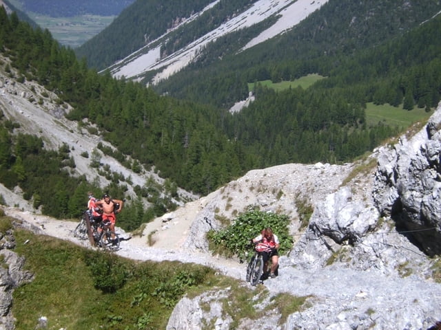
Zunächst gehts am Innradweg flußabwärts bis Sur En. Nun das steile Uinatal rauffahren, bis nach der Einkehr auf der Alm Uina Dadaint die berühmte Uinaschlucht anschließt. Es ist ein in den Fels gesprengter Weg, fahren ist unmöglich. Am Ende der Schlucht schließt ein schön zu fahrender Trial bis zur Sesvennahütte an. Die Mittagspause dort ist sehr zu empfehlen. Die Abfahrt auf der Schotterstraße ist nur am Anfang sehr steil. Nicht nur wegen der Fußgänger könnte es ratsam sein, kurz das Fahrrad zu schieben. Aber dann folgt eine nicht endend wollende Abfahrt bis Burgeis. Von dort fädelt man in den Etschradweg in Richtung Reschenpass ein und fährt auf geteerten Radwegen, am besten am linken Ufer des Reschensees, bis zur Passhöhe und von dort die letzten 200 Hm abwärts bis Nauders.
Hinter dem Bikehotel Central fanden wir die empfehlenswerte Pension Sieglinde, für eine Nacht mit Frühstücksbuffet unter 20 Euro!
Fortsetzung siehe Dreiländer - Achter 2!
Further information at
http://www.dav-tittmoning.de/Bergbeisser/Berichte_2008/Vinschgau/Vinschgau.htmlgaléria trás


Mapa trasy a výškový profil
Minimum height 1133 m
Maximum height 2315 m
More about the tour author
|
|
herzi |
komentáre

GPS trasy
Trackpoints-
GPX / Garmin Map Source (gpx) download
-
TCX / Garmin Training Center® (tcx) download
-
CRS / Garmin Training Center® (crs) download
-
Google Earth (kml) download
-
G7ToWin (g7t) download
-
TTQV (trk) download
-
Overlay (ovl) download
-
Fugawi (txt) download
-
Kompass (DAV) Track (tk) download
-
list trasy (pdf) download
-
Original file of the author (gpx) download
More about the tour author
|
|
herzi |
Add to my favorites
Remove from my favorites
Edit tags
Open track
My score
Rate