
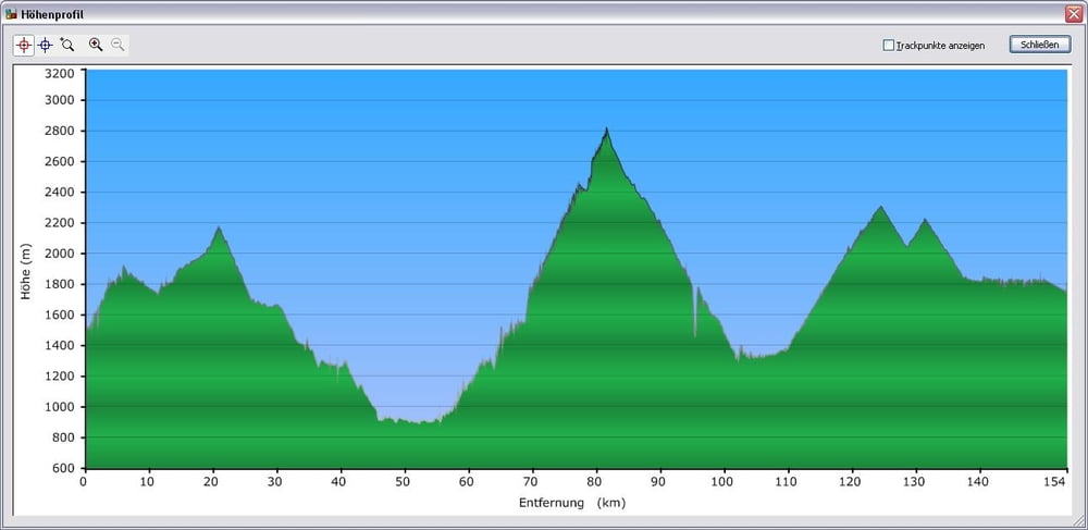

Pässefahrt ab Zernez ca 154 km
- Start Zernez
- Ofenpass ca 20km Aufstieg mässiger Aufstieg.
- Hinunter Richtung Santa Maria weiter nach Prato.
- Passo Stelvio ca 25km langer Aufstieg, die Knaknuss der Tour. Oben angekommen ist die Häfte der Tour geschafft.
- Mit Tempo hinunter Richtung Bormio. Achtung Tunnel sind schmal und nicht beleuchtet, Abzweigung Richtung Livigno nicht verpassen.
- Passo Foscagno ca 12km gleichmässiger Aufstieg.
- Hinunter kleine Erholung!!!
- Passo d`Eira ist nur eine kleine Rampe von ca 3km wer noch über Reserven verfügt sollte einen Sprint hinlegen!!!!
- Hinunter nach Livigno von dort mit Tempo Richtung Schweiz.
- Am Tunnel angekommen muss das Rad in ein Shuttel Bus geladen werden(Kosten einrechnen), Durchfahrt ist nicht neurdings nicht mehr erlaubt.
- Am Zoll angekommen gehts noch locker 5km zu Ova Spin hoch.
- Letzte Abfahrt Richtung Ziel.
galéria trás


Mapa trasy a výškový profil
Minimum height 888 m
Maximum height 2820 m
More about the tour author
|
|
polarsum |
komentáre

GPS trasy
Trackpoints-
GPX / Garmin Map Source (gpx) download
-
TCX / Garmin Training Center® (tcx) download
-
CRS / Garmin Training Center® (crs) download
-
Google Earth (kml) download
-
G7ToWin (g7t) download
-
TTQV (trk) download
-
Overlay (ovl) download
-
Fugawi (txt) download
-
Kompass (DAV) Track (tk) download
-
list trasy (pdf) download
-
Original file of the author (gpx) download
More about the tour author
|
|
polarsum |
Add to my favorites
Remove from my favorites
Edit tags
Open track
My score
Rate