Login

Zabudli ste prihlasovacia meno

Cookies have to be accepted!
Your browser's cookie functionality is disabled. Please enable this functionality.

Not a member yet?

Register now
Login

Available for registred users only

Log in to use this feature.

Zabudli ste prihlasovacia meno

Cookies have to be accepted!
Your browser's cookie functionality is disabled. Please enable this functionality.

Not a member yet?

Register now
Filter
Kategórie
Advanced filters
  • Dĺžka (km)
  • výškomer
Uložiť filter Reset filter

TrackRank

QRCode

Technical data

Dĺžka41,0 km výškomer0 m Way down0 m Doba02:30 h:m dátum16.04.2009
ohodnotenia Author Kraj pôžitok z túry kondícia technika

štatistika

1027 náhľady 2 ohodnotenia 89 Stiahnutia 4.00 priemer
Rate
  • list trasy
  • príjazd
  • Stiahnutia

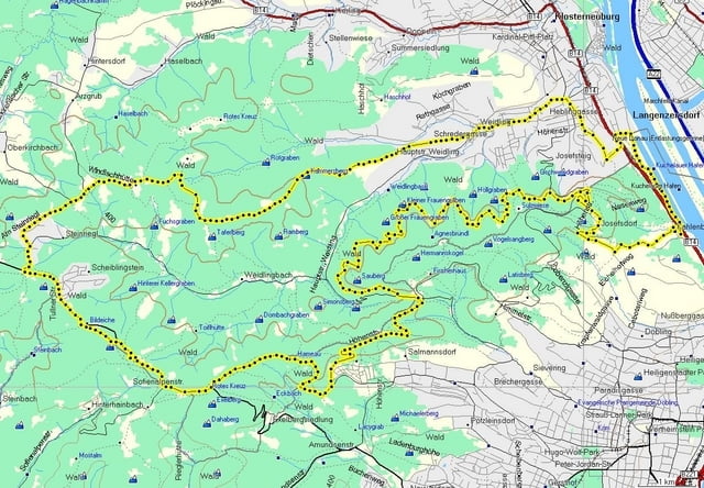
Nette Runde im Wienerwald, nordwestlich von Wien.

Kahlenbergerdorf - Höhenstraße - Sendeanlage Kahlenberg - Hermannskogel - Hameau - Exelberg  - Steinriegl - Windischhütte - Weidling.

Diese Tour zeichnet sich durch einen knackigen Uphill zu Beginn, lässige Waldwege und einige schnelle Abfahrten aus. Eine Rast auf der Windischhütte sollte man sich schon gönnen.


galéria trás

Mapa trasy a výškový profil

  • Open Street Map
  • Google
Minimum height 99999 m Maximum height -99999 m Detailný pohľad

More about the tour author

LeiseRadler
Member since 2008

Send private message

komentáre

Start und Ziel : Kahlenbergerdorf

GPS trasy

Trackpoints
  • GPX / Garmin Map Source (gpx) download
  • TCX / Garmin Training Center® (tcx) download
  • CRS / Garmin Training Center® (crs) download
  • Google Earth (kml) download
  • G7ToWin (g7t) download
  • TTQV (trk) download
  • Overlay (ovl) download
  • Fugawi (txt) download
  • Kompass (DAV) Track (tk) download
  • list trasy (pdf) download
  • Original file of the author (gpx) download

More about the tour author

LeiseRadler
Member since 2008

Send private message
Share track
Add to my favorites
Remove from my favorites
Edit tags
My score
Rate
trasa: Windischhüttenrunde
Druh: horský bicykel
Dĺžka: 41,0 km
Evaluated on:
Doba:
Day(s)
Hour(s)
Minute(s)
ohodnotenie: Kraj pôžitok z túry kondícia technika