Login

Zabudli ste prihlasovacia meno

Cookies have to be accepted!
Your browser's cookie functionality is disabled. Please enable this functionality.

Not a member yet?

Register now
Login

Available for registred users only

Log in to use this feature.

Zabudli ste prihlasovacia meno

Cookies have to be accepted!
Your browser's cookie functionality is disabled. Please enable this functionality.

Not a member yet?

Register now
Filter
Kategórie
Advanced filters
  • Dĺžka (km)
  • výškomer
Uložiť filter Reset filter

TrackRank

QRCode

Technical data

Dĺžka46,1 km výškomer1537 m Way down1495 m Doba00:00 h:m dátum23.09.2006
ohodnotenia Author Kraj pôžitok z túry kondícia technika

štatistika

5364 náhľady 3 ohodnotenia 648 Stiahnutia 4.00 priemer
Rate
  • list trasy
  • príjazd
  • Stiahnutia
Sehr schöne, lange und insbesondere kurz vor dem Hundsstein-Gipfel sehr steile Tour.
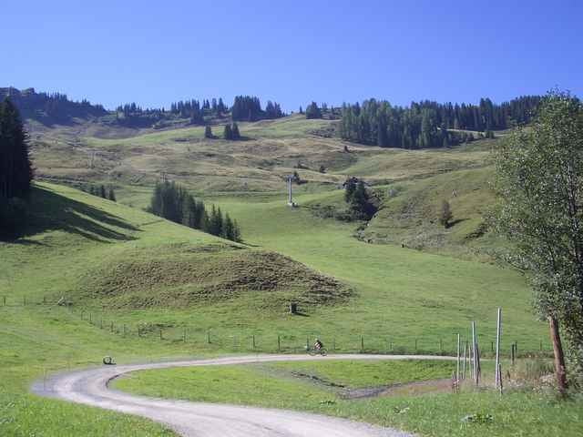
Auffahrt von Maria Alm aus durch das Schigebiet zum Statzerhaus; Abfahrt Richtung Zeller See und zurück nach Maria Alm über den Tauernradweg

galéria trás

Mapa trasy a výškový profil

  • Open Street Map
  • Google
Minimum height 759 m Maximum height 2118 m Detailný pohľad

More about the tour author

Horski

komentáre

padibike on 13.06.2007

Hundssteinrunde von Maria Alm aus

Dies ist eine der landschaftlich schönsten Bikerunden die ich kenne, anspruchsvoll, aber mit ein wenig Kondition und Ausdauer gut zu bewältigen. Man kann ja auch einmal pausieren.

GPS trasy

Trackpoints
  • GPX / Garmin Map Source (gpx) download
  • TCX / Garmin Training Center® (tcx) download
  • CRS / Garmin Training Center® (crs) download
  • Google Earth (kml) download
  • G7ToWin (g7t) download
  • TTQV (trk) download
  • Overlay (ovl) download
  • Fugawi (txt) download
  • Kompass (DAV) Track (tk) download
  • list trasy (pdf) download
  • Original file of the author (gpx) download

More about the tour author

Horski

Share track
Add to my favorites
Remove from my favorites
Edit tags
My score
Rate
trasa: Hundsstein-Runde von Maria Alm aus
Druh: horský bicykel
Dĺžka: 46,1 km
Evaluated on:
Doba:
Day(s)
Hour(s)
Minute(s)
ohodnotenie: Kraj pôžitok z túry kondícia technika