Login

Zabudli ste prihlasovacia meno

Cookies have to be accepted!
Your browser's cookie functionality is disabled. Please enable this functionality.

Not a member yet?

Register now
Login

Available for registred users only

Log in to use this feature.

Zabudli ste prihlasovacia meno

Cookies have to be accepted!
Your browser's cookie functionality is disabled. Please enable this functionality.

Not a member yet?

Register now
Filter
Kategórie
Advanced filters
  • Dĺžka (km)
  • výškomer
Uložiť filter Reset filter

TrackRank

QRCode

Technical data

Dĺžka18,3 km výškomer102 m Way down100 m Doba02:06 h:m dátum26.12.2010
ohodnotenia Author Kraj pôžitok z túry kondícia technika

štatistika

516 náhľady ohodnotenia 29 Stiahnutia priemer
Rate
  • list trasy
  • príjazd
  • Stiahnutia

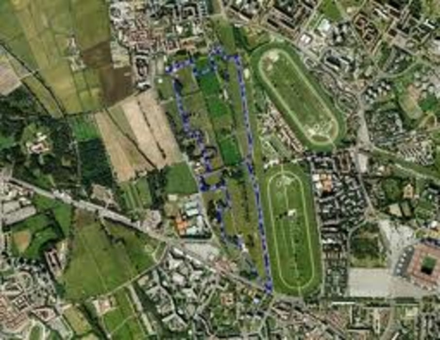
 Un giro di 18 Km per chi a Milano Ovest cerca il giusto compromesso tra una buona distanza ed un tracciato non ripetitivo e noioso

Mapa trasy a výškový profil

  • Open Street Map
  • Google
Minimum height 119 m Maximum height 150 m Detailný pohľad

More about the tour author

noplo
Member since 2010

Send private message

komentáre

 Si può parcheggiare in qualsiasi punto del tracciato, preferibilmente al Parco delle Cave, Parco Trenno o la Montagnetta di San Siro.

GPS trasy

Trackpoints
  • GPX / Garmin Map Source (gpx) download
  • TCX / Garmin Training Center® (tcx) download
  • CRS / Garmin Training Center® (crs) download
  • Google Earth (kml) download
  • G7ToWin (g7t) download
  • TTQV (trk) download
  • Overlay (ovl) download
  • Fugawi (txt) download
  • Kompass (DAV) Track (tk) download
  • list trasy (pdf) download
  • Original file of the author (gpx) download

More about the tour author

noplo
Member since 2010

Send private message
Share track
Add to my favorites
Remove from my favorites
Edit tags
My score
Rate
trasa: Cave-Trenno-Montagnetta
Druh: beh
Dĺžka: 18,3 km
Evaluated on:
Doba:
Day(s)
Hour(s)
Minute(s)
ohodnotenie: Kraj pôžitok z túry kondícia technika